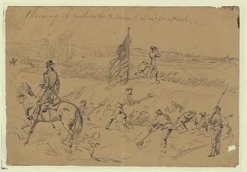
It seems intuitive that if someone is firing bullets at you, you seek cover, and if no tree or rock or fence is available, to build something protective to hide behind.  Yet, the U.S. Civil War was the first armed conflict in which extensive trenches were created. At the beginning, soldiers lined up and fired at those in the opposing line at point-blank range. But the death toll was outrageous; by the end of the war, picks and shovels became as much a part of fighting as artillery and guns.

Lloyd W Klein MD explains.

Entrenchments (also called field fortifications or earthworks) were widely used during the American Civil War,  becoming increasingly important as the war progressed.. Trench warfare was not as prevalent as in later conflicts. Except for sieges of fortified cities, combat in the past had been of short duration, major battles rarely lasting for more than a day. Early in the Civil War, we don’t see entrenchments at places like Manassas, Shiloh, or Antietam. While fighting behind stone walls and other make-shift barriers was resorted to at various locations, such as Gettysburg, the concept of “digging in” wasn’t prevalent until much later. Nevertheless, the development of trench warfare tactics in the Civil War foreshadowed their extensive use in future conflicts.

In discussing entrenchments, therefore, we are not talking about pre-existing stone walls (e.g., Marye’s Heights at Fredericksburg) or terrain features (e.g., the Sunken Road at Antietam or Little Round Top at Gettysburg). A "trench" is a deep, long ditch dug into the ground to provide shelter for soldiers from enemy fire, while a "breastwork" is a temporary fortification typically made of earth, built up to chest height, allowing soldiers to fire over it while remaining partially protected from enemy fire; essentially, a breastwork is a more shallow, elevated defensive structure compared to a trench which is a deeper, dug-out ditch. Trenches are significantly deeper than breastworks, often allowing soldiers to stand upright within them. Trenches are dug into the ground, while breastworks are often built up from loose earth or sandbags, sometimes on top of a shallow ditch. While both offer protection, trenches generally provide better cover against heavy artillery and gunfire due to their depth.


Trench Construction

The construction of trenches during the Civil War was a labor-intensive process that required organization, manpower, and tools. Commanders would first decide on the location and layout of the trench system. This planning involved selecting high ground when possible, avoiding natural obstacles, and creating a network that provided defensive depth and coverage. Engineer officers would generally plan and supervise.  Engineer regiments would assist, if available, but they were limited in number.  Most of the work was performed by detailed infantry, perhaps assisted by black labor, free or enslaved, depending on which side.

Soldiers would begin digging the main trench line, typically starting with a shallow trench and gradually deepening it. The soil removed was piled up to create a parapet (a protective wall) in front of the trench to provide additional cover and protection.

Proper drainage was essential to prevent water from accumulating in the trenches. Soldiers would dig drainage ditches and sometimes line the trench floor with wooden planks (duckboards) to keep it dry and prevent mud.

Trenches were often camouflaged to blend in with the surrounding terrain and reduce their visibility to the enemy. Soldiers would use natural vegetation, earth, and other materials to disguise their positions.

“Saps" would be dug forward from an existing trench line, and the new trench extended laterally from there. In addition to the main front-line trenches, support trenches were dug behind the front lines to serve as secondary defensive positions, supply routes, and communication lines. These trenches were connected by communication trenches, which allowed safe movement of troops and supplies between different parts of the trench system..


A typical rifle trench or field fortification included several features.

·       Parapet: The mound of earth in front, created from the soil dug from the trench. Protected soldiers from enemy fire.

·       Firing step (banquette): A raised step inside the trench allowing soldiers to stand and fire over the parapet.

·       Ditch: The trench itself, usually 4–6 feet deep and wide enough to allow movement.

·       Revetments: Logs, planks, gabions (cylindrical baskets filled with dirt), or sod used to reinforce trench walls.

·       Traverses: Earth barriers placed at intervals inside the trench to reduce the impact of enfilading fire.

Additional features of a sophisticated trench system might include:

·       Bombproofs: Underground shelters made with logs and dirt to protect from artillery.

·       Artillery platforms: Raised areas behind the main trench where cannons were mounted.

·       Communication trenches: Smaller connecting trenches used to move troops and supplies safely.

The construction process was continuous, with soldiers constantly improving and expanding their trench networks to adapt to the evolving battlefield conditions. The resulting trench systems could become extensive and complex, providing significant defensive advantages in the static, attritional warfare that characterized the later stages of the Civil War.

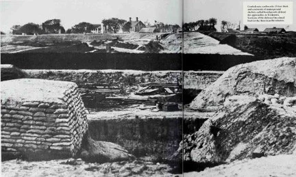
The area surrounding Corinth, Mississippi, was fortified heavily by the Union and Confederate forces who struggled to control the strategically important town. Today, those earthworks are some of the best-preserved in the country. Halleck conceived of Corinth as a quasi-siege, and the concept of building ever-closer lines was a siege stratagem.

Fortifications were made from mounded soil, baskets, timber, and even bales of cotton were very effective. Earth and sod were the primary materials, because they absorbed bullets and shell fragments better than wood or stone. Gabions (wicker baskets filled with earth) were used to reinforce the trenches. To prevent the trench walls from collapsing, soldiers reinforced them with logs, planks, or other materials. In some cases, trenches were lined with sandbags or gabions to stabilize the walls and absorb enemy fire. Trenches were often supplemented with additional fortifications such as earthworks, redoubts (enclosed defensive structures), and gun emplacements. Obstacles like abatis (felled trees with sharpened branches), wire entanglements, and chevaux-de-frise (spiked barriers) were placed in front of the trenches to hinder enemy assaults.

A  variety of tools were used to dig trenches, including shovels, picks, axes, spades, and occasionally makeshift tools. Soldiers themselves did the digging early on. Over time, both the Union and Confederate armies developed engineering units to supervise and speed up construction.


Increasing Utilization During the War

The underlying reasons for their increasing popularity as the war continued were improved technology, which had intensified firepower, and crippling deficiencies in communication, which technology had not yet solved. Field entrenchments were a response to progress in weapons technology. Rifle muskets, deadly accurate at several hundred yards, and close-order field artillery made previous battle tactics obsolete. The earthworks were designed to protect troops against this increased firepower. When McClellan advanced from Yorktown in the direction of Richmond, his progress was slowed by an outnumbered Confederate rearguard, which gave ground only grudgingly on a wide front. This was possible because no longer did men need to be packed into tight ranks in order to generate sufficient volume of fire to maintain their position against assault. Reciprocally, the thinning out of ranks made them less vulnerable to incoming fire. Such gams were ameliorated further when men took to lying down to shoot or, better still, made a point of firing from trenches or behind cover instead of standing up in the open, as in Napoleonic Wars or other European conflicts. As had been shown in the Crimea and at Solferino, head-on assaults against a well-emplaced enemy were no longer profitable operations of war. Even less viable was cavalry against modern artillery and rifle fire. Although neither army was yet able to apply the full devastating potential of modern weapons, and many old, muzzle-loading rifles were still in service, the Sharps and Spencer rifles were coming into use.


Early War Use (1861–1862)

At the beginning of the war, both Union and Confederate commanders favored offensive tactics and quick, decisive battles. There was a general belief that the war would be short, and both sides sought to achieve swift victories through aggressive maneuvers and direct engagements.

Many of the early commanders and soldiers lacked experience in modern warfare and did not initially appreciate the defensive advantages that entrenchments could provide. They were more accustomed to traditional Napoleonic tactics, which emphasized open-field battles and charges. Early in the war, entrenchments were used sparingly, mainly around forts, strategic river crossings, or defensive cities. The full impact of rifled muskets and artillery was not yet fully understood. As the war progressed, the increased range and accuracy of these weapons made entrenched positions more valuable for defense. Initially, commanders did not see the necessity for extensive fortifications.

At first, the strategic use of trenches was more limited and often makeshift. Trenches were used mainly for protection rather than extended combat. Building extensive entrenchments required significant time, labor, and resources. Early in the war, armies were more mobile and focused on quick movements and engagements rather than static defenses. There was also a psychological aspect to avoiding entrenchments. Many soldiers and commanders viewed digging in as a sign of weakness or lack of courage. They believed that bold offensive actions were more honorable and likely to bring victory.

However, battlefields like Yorktown (Peninsula Campaign, 1862) saw early use of extensive trenches by both Confederate and Union forces. When McClellan advanced from Yorktown in the direction of Richmond, his progress was slowed by an outnumbered Confederate rearguard, which gave ground only grudgingly on a wide front. This was possible because no longer did men need to be packed into tight ranks in order to generate sufficient volume of fire to maintain their position against assault. Reciprocally, the thinning out of ranks made them less vulnerable to incoming fire. Such gams were ameliorated further when men took to lying down to shoot or, better still, made a point of firing from trenches or behind cover instead of standing up in the open.

Battles like Antietam and Shiloh showed that lining up and firing wasn’t a winning tactic. As the war progressed and the brutal realities of modern warfare became apparent, the use of entrenchments increased significantly. The high casualties from direct assaults and the effectiveness of defensive positions in battles like Fredericksburg and Gettysburg led to a greater emphasis on fortifications. By the later stages of the war, trench warfare had become a common feature, culminating in the protracted sieges of Petersburg and other battles. By the end of the war, trench warfare had become the dominant mode of combat. The Union had some success with a new alignment of attacking forces at Spotsylvania Courthouse but in general, it became about how to deal with an entrenched enemy.


Shift to Entrenched Warfare (1863–1864)

Entrenchments became far more common as the war continued. Experience on many battlefields taught generals and soldiers that rifled muskets and artillery made frontal assaults deadly. The increased firepower and longer campaigns took their toll;  armies began digging in to protect themselves during sieges or static operations. Increasingly, it was the best defensive strategy, especially for Rebel armies. Confederates, often outnumbered, used trenches to hold ground more effectively.


Key Examples of Entrenchments

Battle of Vicksburg (May-July 1863): The Siege of Vicksburg involved extensive entrenchments by both Union and Confederate forces. The Union Army, under General Ulysses S. Grant, besieged the city, and Confederate defenders used fortifications to hold off the attackers for over 40 days before surrendering. The fall of Vicksburg was a turning point in the war, giving the Union control of the Mississippi River.


Chattanooga (1863) – Confederates entrenched on Lookout Mountain and Missionary Ridge.

Overland Campaign (1864) –

The Battle of Spotsylvania Court House (May 8-21, 1864) is another significant example where entrenchments played a crucial role. During this battle, which was part of the Overland Campaign, both Union and Confederate forces used extensive entrenchments. The most famous segment of the battle occurred at the "Bloody Angle," a section of the Confederate defensive works. At Spotsylvania, the unique earthworks straddled a ravine located on a hillside that ascends 12 feet over 30 yards. The defense was composed of three sets of trenches. The main line of trenches was composed of 11 steps with a traverse trench running along the side. The traverse trench connected all of the steps leading to the top of the hill. The other sets of trenches, just to the west of the main line, are constructed in the same fashion, but were significantly smaller than those along the mainline. Needless to say, this design was unlike any other fortifications in the Civil War.

Battle of Cold Harbor (May-June 1864): Confederate forces under General Lee were heavily entrenched, and Union forces led by General Grant suffered severe casualties in frontal assaults. The entrenched positions contributed to one of the war's most lopsided battles in terms of casualties. Union troops faced massive casualties assaulting well-dug Confederate lines.

Battle of Petersburg (June 1864-April 1865 – Perhaps the most significant use of trench warfare in the war. A 9-month siege with 30+ miles of trenches anticipated WWI-style warfare. Both sides built elaborate networks of trenches and fortifications. The Union forces, led by General Grant, eventually broke through the Confederate lines, leading to the fall of Richmond and the end of the war. Grant kept trying to swing around Lee's right and left flanks during the siege of Richmond and Petersburg. This eventually forced Lee to abandon his lines because he could not sufficiently man the ever-expanding defensive line that Grant imposed on him. Once dislodged, Grant turned Sheridan loose to cut off Lee's move west while the bulk of his army pushed in on Lee.


Petersburg

The most advanced form of trench warfare was observed in the Petersburg campaign in 1864. The defense of Petersburg by General Pierre Gustave Toutant Beauregard is often regarded as both bold and brilliant. He counterattacked Grant’s forward forces periodically to delude the Union army into believing his thinly spread force was much stronger. Meanwhile, he had his engineers building trenches, so that after 3 days, he was able to fall back into a defendable position. One quick determined rush by a Corps on 15th June 1864 might well have broken through. I can never understand why a man of Beauregard’s genius could not find a more central role in the Confederate army.

By June 18th, the trenches were so sophisticated that an army of 65,000 was insufficient to overcome the 40,000 men Lee had rushed to the spot by rail. Faced at first by an improvised line, the initial Federal assault failed from lack of co-ordination. Detachments advanced independently, inadequately supported by artillery, and were pinned to the ground by fire of only moderate intensity. By the time a set-piece attack could be launched on the 18th, the volume of defensive fire was annihilating, compelling Grant to call a halt and commence probing the city’s southern flank with a view to isolating it.

Keeping pace with each Federal sidestep to their left, the Confederates extended their entrenchment to their right, always in time to meet each assault while fiercely contesting Grant’s further attempts to cut the railroad line to Richmond or the one running westward from Petersburg. Assault was usually of the battering-ram sort – a blasting of the selected point of attack by artillery and mortars (the latter, with their plunging fire, being particularly suitable for striking at the deeper enemy emplacements) followed by a massed infantry charge.

Petersburg is the first instance of the use by the Union Army of the rapid-fire gun, the important precursor to modern-day machine guns. Twelve of the guns were purchased personally by Union commanders. The Gatling gun was a rapid-firing multiple-barrel firearm invented in 1861 by Richard Jordan Gatling. The Gatling gun's operation centered on a cyclic multi-barrel design which featured multiple rotating barrels powered by a hand crank, capable of firing several hundred rounds per minute. This design facilitated cooling and synchronized the firing-reloading sequence. As the hand wheel was cranked, the barrels rotated, and each barrel sequentially loaded a single cartridge from a top mounted magazine, firing the shot when it reached a set position (usually at 4 o'clock), then ejects the spent casing out of the left side at the bottom, after which the barrel is empty and allowed to cool until rotated back to the top position and gravity-fed another new round. This configuration eliminated the need for a single reciprocating bolt design and allowed higher rates of fire to be achieved without the barrels overheating quickly.


The Dimmock Line

The Dimmock Line was a series of Confederate defensive earthworks constructed to protect Petersburg. It was named after Captain Charles H. Dimmock, a Confederate engineer who designed it in 1862. Its length was 10 miles, forming a semicircle around the eastern and southern approaches to Petersburg, and incorporated 55 numbered artillery redans (small forts) connected by infantry trenches with both flanks anchored on the Appomattox River. It was built by enslaved laborers and Confederate soldiers. The Dimmock Line was initially effective in delaying Union forces during the early days of the siege, but Grant’s forces eventually extended around the line. Union troops finally attacked Petersburg directly, and elements of the Dimmock Line fell in mid-June 1864, which began the Petersburg Campaign. The Dimmock Line is historically significant as one of the earliest large-scale uses of entrenched field defenses in modern warfare, showing the transition from open battle to static, fortified lines.


Battle of the Crater

Digging a tunnel under the trenches and blowing it up seems like the most obvious and simple thing in the world. One of the most notable examples is the Battle of the Crater during the Siege of Petersburg (July 30, 1864). The mine built under the Confederate Lines at the Battle of the Crater was anything but simple. Although Grant and Meade were aware of its construction, neither expected any tactical benefit and seemed to have lost interest in it.

The Attack at the Redoubt at Petersburg on July 30th is the “correct” name of what is known as the Battle of the Crater. A mine containing four tons of black powder was detonated beneath the redoubt and its defenders. Placed in a cross shaft at the end of a 511-foot tunnel that a regiment of coal miners secretly dug, it was blown at dawn without warning to the enemy. General Ambrose Burnside, whose four divisions of infantry were to exploit the explosion, seems to have relied too much upon the shock effect of the mine; beyond doubt, the measures he took to ensure that the troops not only occupied the crater but pressed on rapidly beyond were ambiguous and unambitious. As for the troops, so staggered were they by the enormity of the explosion, the air pressure of its blast and the scene of carnage which met their eyes when they poured into the crater, that they lost all sense of purpose and stayed there all morning, poking about among the grisly ruins of dismembered men and equipment.

Lt. Col. Henry Pleasants originated the concept, commanding the 48th Pennsylvania Infantry of Major General Ambrose E. Burnside's IX Corps, Pleasants, a mining engineer from Pennsylvania in civilian life, proposed digging a long mine shaft under the Confederate Army lines and planting explosive charges directly underneath a fort (Elliott's Salient) in the middle of the Confederate First Corps line. If successful, not only would all the defenders in the area be killed, but also a hole in the Confederate defenses would be opened. If enough Union troops filled the breach quickly enough and drove into the Confederate rear area, the Confederates would not be able to muster enough force to drive them out, and Petersburg might fall.

Union forces, under the command of General Ambrose Burnside, devised a plan to break the Confederate lines at Petersburg by digging a mine underneath the Confederate fortifications. A regiment of Pennsylvania coal miners was tasked with digging the tunnel, which extended over 500 feet to a point beneath the Confederate defenses. Burnside, whose reputation had suffered from his 1862 defeat at the Battle of Fredericksburg and his poor performance earlier that year at the Battle of Spotsylvania Court House, was looking for a way to improve his military reputation.

The tunnel ran 510.8 feet. The shaft was dug with an upward incline to ensure water drainage. One-third of the way, the miners struck a vein of unworkable stone, so they further increased the slope to avoid it. Fresh air was drawn in by an ingenious air-exchange mechanism near the entrance. A canvas partition isolated the miners' air supply from outside air and allowed miners to enter and exit the work area easily. The miners had constructed a vertical exhaust shaft located well behind Union lines. At the vertical shaft's base, a fire was kept continuously burning. A wooden duct ran the entire length of the tunnel and protruded into the outside air. The fire heated stale air inside of the tunnel, drawing it up the exhaust shaft and out of the mine by the chimney effect. The resulting vacuum then sucked fresh air in from the mine entrance via the wooden duct, which carried it down the length of the tunnel to the place in which the miners were working. That avoided the need for additional ventilation shafts, which could have been observed by the enemy, and it also easily disguised the diggers' progress.

Lee had intelligence of my construction but made no reaction for 2 weeks. Finally, he initiated some minimal attempts to identify its location, but never did. Shafts were sunk but never found.


The mine was “T” shaped. Its entrance was narrow and 50 feet below the Confederate line. At the end was a 75-foot perpendicular shaft into which the explosives were placed.

Union soldiers filled the mine with 320 kegs of black (gun) powder, totaling 8,000 pounds. The explosives were approximately 20 feet under the Confederate works, and the T-gap was packed shut with 11 feet of earth in the side galleries. A further 32 feet of packed earth was placed in the main gallery to prevent the explosion from blasting out the mouth of the mine.

The mine was detonated on the morning of July 30, 1864. The explosion created a massive crater, killing or wounding hundreds of Confederate soldiers and creating a breach in their lines. Despite the initial success of the explosion, the follow-up assault by Union troops was poorly executed. Confusion, miscommunication, and ineffective leadership led to a chaotic and ultimately failed attack. Confederate forces regrouped and launched counterattacks, inflicting heavy casualties on the Union troops who had entered the crater. The Union assault ended in disaster, and the Confederate lines held.


The reasons for the limited Use of mines included:

·       Technical Challenges: Digging mines required specialized skills and knowledge, which were not always available in sufficient quantities. The process was labor-intensive and time-consuming, making it difficult to employ on a large scale.

·       Strategic Focus: Early in the war, both sides focused on traditional offensive and defensive tactics rather than siege warfare. As the war progressed and trench warfare became more common, the use of mining techniques increased, but it never reached the scale seen in World War I.

·       Resource Constraints: Mining operations required significant resources, including labor, explosives, and time. Both Union and Confederate forces often faced logistical challenges that limited their ability to conduct large-scale mining operations.

·       Effectiveness: While mines could create breaches in enemy lines, the effectiveness of such tactics depended on the ability to exploit the breach quickly and effectively. As seen in the Battle of the Crater, poor execution of follow-up attacks could negate the initial success of the mine explosion.


Overall, while mines were used during the Civil War, their employment was limited by technical, logistical, and strategic factors. The Battle of the Crater stands out as a significant example of mining in the Civil War, highlighting both the potential and the challenges of this tactic.


Impact and Legacy

Entrenchments slowed campaigns, turning mobile warfare into grinding, attritional battles.

They foreshadowed trench warfare in World War I, especially the siege at Petersburg.

They reflected how military technology had advanced faster than tactics, forcing adaptation.


The site has been offering a wide variety of high-quality, free history content since 2012. If you’d like to say ‘thank you’ and help us with site running costs, please consider donating here.


Further Reading

·       https://gettysburgcompiler.org/2020/12/09/unsolved-mystery-of-the-galleries-sixth-corps-trenches-at-spotsylvania-court-house/

·       https://www.thecanadianencyclopedia.ca/en/article/trench-warfare

·       http://www.petersburgproject.org/trench-warfare-in-civil-war-history.html

·       https://www.battlefields.org/learn/articles/something-new-art-war-civil-war-earthworks-and-trenches

·       https://weaponsandwarfare.com/2019/01/08/trench-warfare-in-the-american-civil-war/

The story of Roman trade within southern India in the first through third centuries CE reads like a tale of winds, waves, and the sudden compression of distance. For centuries before, goods had moved slowly along overland and coastal networks, but the exploitation of the southwest and northeast monsoon winds transformed the Arabian Sea into a predictable highway.

Terry Bailey explains.

A map said to date from 1597 by Abraham Ortelius. It depicts the locations of the Periplus of the Erythraean Sea.

From Egyptian Red Sea entrepôt (a transshipment port) such as Berenice and Myos Hormos Roman merchants — operating under the political umbrella of imperial Egypt but largely as private entrepreneurs and syndicates, loaded cargoes when the seasonal winds turned, thereby crossing directly to the ports of the Malabar Coast. The result was not a brief flirtation but sustained, documented commerce that reshaped consumption in both regions and left a clear archaeological footprint centuries later.

Knowledge of the monsoon pattern is central to this maritime revolution. Ancient writers attribute the practical discovery of the direct wind route across the open Arabian Sea to the mariner Hippalus, whose name is attached in later sources to the seafarer who realized that the monsoon could be used to make a rapid crossing. The most vivid contemporary guide to the mechanics of those voyages and the ports they serviced is the Periplus of the Erythraean Sea, a pragmatic merchant's handbook written in Greek in the first century CE.

The Periplus instructed captains on seasons for departure, sailing distances, and the goods exchanged, and it explicitly links Egyptian Red Sea harbors with Indian anchorages such as Muziris on the Malabar Coast and farther east and north to ports like Nelkunda and Barygaza. Other Greco-Roman authors, notably Strabo, Ptolemy and Pliny the Elder repeated and amplified these observations: Pliny famously lamented the enormous outflow of Roman bullion to the East and thereby provides contemporary testimony to the scale and significance of the trade, even if his tone is moralizing.

The logistics of these missions were anchored in Egypt. Following Augustus' secure control of Egypt, Roman commerce could reach the Red Sea ports under relatively reliable conditions. Berenice and Myos Hormos (the latter likely corresponding to the later Quseir region) functioned as staging points where cargoes from the Mediterranean — wine, olive oil, glassware, fine metalwork, and coins were trans-shipped into Red Sea craft. Roman captains timed departures to the monsoon: ships would ride the southwest monsoon out of the Red Sea, cross the Arabian Sea in weeks rather than months, and then use the returning northeast monsoon for the homeward voyage. This seasonal rhythm structured an annual trading circuit and made repeated, large-scale exchanges possible rather than one-off ventures.


On the Indian side, the principal destinations were the sheltered estuaries and backwaters of the Malabar Coast. Muziris, long considered the primary Roman-era entrepôt in southern India appears repeatedly in the Periplus as a hub for pepper, pearls, timber and other highly prized products. Other nodes, including the entrepôts at Arikamedu near modern Pondicherry and the trading emporia around the mouth of the Periyar River, provided additional access to inland producers.

The distribution network within India routed commodities from interior markets and coastal fisheries toward these harbors, where foreign merchants met local brokers, guilds and rulers willing to trade access for customs and gifts. This commodity mix explains why Romans were willing to sail such long distances. Southern India supplied pepper, spices, pearls, ivory, aromatic woods, and precious gems, items that could command fortunes in Roman urban markets.

In return, Roman consumers sent gold and silver, wine and olive oil, fine tablewares, glassware, and coins; Roman manufactures and Mediterranean foods had status and practical demand. The Periplus and other texts catalogue these categories with a trader's eye, and the economic consequences are visible in Roman commentary: Pliny's remarks that gold poured out of the Empire into the East reflecting a structured trade imbalance that contemporary Romans noticed and debated.

Archaeology has provided the most persuasive confirmation that the Periplus and classical authors were not merely repeating traders' tall tales. Excavations at sites on the Indian coast have turned up unequivocal Roman material, amphorae sherds of Mediterranean types, terra sigillata and other fine wares, intaglios, glass fragments and Roman coins, demonstrating repeated contacts over centuries. The site long identified as Arikamedu produced large quantities of Roman ware and Mediterranean glass and has been dated by stratigraphy and finds to the early centuries of the Common Era; its imported assemblage fits neatly with Periplus descriptions of northeastern Indian trade.

On the Malabar side, substantial finds at several Kerala sites, most controversially at Pattanam, where archaeologists have reported Roman amphorae, Mediterranean ceramics, beads, and other imported items point toward a busy port landscape that traded directly with Roman ships. Although the precise identification of Pattanam with ancient Muziris remains debated among specialists, the material evidence from the region shows a dense, long-term network of maritime exchange during the first three centuries CE.

Beyond ceramics and coins, the movement of organic and botanical goods is reflected with indirect but telling finds. Roman settlements and villas around the Mediterranean display evidence of Indian spices and resins, while excavations at Pompeii and other Roman towns have yielded peppercorns and traces of eastern spices in kitchens and storehouses, showing that Indian condiments were incorporated into Mediterranean culinary life.

Conversely, Indian coastal deposits include Mediterranean amphora fragments whose shapes and stamps can be typologically dated to the early imperial period; these amphorae once contained wine and oil that were desirable enough to import across thousands of kilometers of sea. Numismatic and epigraphic evidence further corroborates the intensity of contact. Roman coins — denarii and aurei — appear in southern Indian hoards and contexts, sometimes in significant quantities, indicating monetary exchanges rather than mere occasional barter. Likewise, Indian inscriptions and later classical sources mention the presence of foreign merchants and sometimes tax arrangements. A handful of Roman goods, including high-status glass and metal objects, have been found in local elite contexts, suggesting the circulation of prestige items and diplomatic gifts alongside market trade.

Material connections were matched by cultural interactions. Roman motifs appear in local art, and Indian goods circulated through Roman markets and households. The trade brought wealth and exotic goods to coastal polities, and it also produced a network of agents, interpreters and middlemen whose livelihoods depended on interregional exchange. The pattern was not one of wholesale colonization but of sustained commercial entanglement: caravan routes, riverine feeders and local markets in southern India integrated the region into a broader Indian Ocean economy in which Roman demand played a strong role.

Scholars continue to refine the picture. New excavations, improved typologies for dateable Mediterranean sherds, residue analysis of amphora contents, and better numismatic chronologies have all tightened the temporal contours of the trade and exposed its fluctuations: periods of intense activity, phases when political instability or piracy depressed traffic, and the later attenuation of direct Roman-Indian commerce as intervening powers and new maritime networks reconfigured the Indian Ocean. Yet across those shifts, the archaeological record and the contemporary written sources together make a coherent case that in the first and third centuries CE, Roman merchants used the monsoon winds in predictable seasonal circuits from Egyptian Red Sea ports to Indian anchorages, where those voyages established a long-running exchange that left tangible traces in the ground and in the literature.

Viewed together, text and trowel give complementary insight. The Periplus and Greco-Roman authors supply the practical vocabulary of sailing seasons, cargo types and port names; the archaeological record supplies the tangible residues — amphora fragments, coins, glass and exotic botanical remains — that prove sustained contact. The Roman-Indian trade of the early imperial centuries is therefore not an abstract line on a map but a lived, seasonal choreography of sailors, brokers and coastal communities whose exchange of goods transformed taste, wealth and connectivity across two very different maritime worlds.

In conclusion, the maritime trade between Rome and southern India during the first through third centuries CE stands as one of antiquity's most remarkable examples of long-distance commercial integration. What began as an experiment in harnessing the monsoon winds became a sustained and organized exchange that compressed the vast distances between the Mediterranean and the Indian Ocean into a manageable, predictable circuit of travel. This trade was not merely the movement of goods across seas but the development of a cross-cultural ecosystem in which Roman and Indian societies profoundly influenced one another — economically, materially, and even symbolically.


The combination of literary testimony and archaeological discovery has transformed what might once have seemed a romantic episode of ancient seafaring into a well-documented reality. The Periplus of the Erythraean Sea and the observations of classical geographers provided the framework, while the excavation of Red Sea ports such as Berenice and Indian coastal sites like Arikamedu and Pattanam filled in the empirical detail. Together, they reveal a world in motion: Roman merchants timing their departures with the monsoon's turn, Indian traders and rulers orchestrating the flow of inland produce to meet foreign demand, and both sides adapting to a rhythm of seasonal winds that dictated the tempo of a globalized economy centuries before the modern age.

The economic consequences of this transoceanic connection were immense. Roman markets developed a lasting appetite for Indian luxuries — pepper, pearls, spices, ivory and gems — while Indian elites gained access to Roman coin, glass, and fine wares that signified wealth and prestige. The imbalance lamented by Pliny the Elder, in which gold drained eastward, is not merely a rhetorical flourish but an early reflection on international trade deficits and the complex dependencies that arise from them. Yet this exchange was not exploitative conquest but negotiated interdependence: each side held what the other desired, and through mutual adaptation, both prospered.

Culturally, the trade's influence rippled far beyond the harbors. Artistic motifs, technologies, and tastes circulated with the goods, while evidence of Indian spices in Roman kitchens and Roman coins in Indian hoards testifies to a two-way diffusion of material culture. These exchanges subtly redefined notions of luxury, identity, and worldliness across both regions. The merchants, translators, and sailors who navigated this network became agents of connectivity, knitting the Mediterranean and Indian Ocean basins into one of the earliest examples of a truly intercontinental economy.

Ultimately, the Roman–Indian maritime trade illuminates a broader human story of curiosity, enterprise, and the pursuit of opportunity across the natural boundaries of geography. The monsoon winds, once a barrier, became a bridge linking two great civilizations. Through their shared engagement with the sea, Rome and India participated in a dynamic, centuries-long dialogue of commerce and culture whose traces still gleam in amphora shards, peppercorns, and ancient coins unearthed on opposite sides of the ocean. It remains a vivid testament to how ingenuity and exchange can reshape entire worlds, and how the tides of history often flow along the same routes as the winds that once filled ancient sails.


The site has been offering a wide variety of high-quality, free history content since 2012. If you’d like to say ‘thank you’ and help us with site running costs, please consider donating here.


Notes:

Periplus of the Erythraean Sea

The Periplus, (περίπλους and transliterated as períplous), of the Erythraean Sea is one of the most remarkable maritime documents to survive from the ancient world. Written in Greek during the mid-first century CE, it serves as both a navigational guide and a commercial handbook for sailors and traders navigating the waters of the Red Sea, Arabian Sea, and the western Indian Ocean. The term periplus itself means "sailing around" in Greek, and the work provides a detailed account of coastal landmarks, ports, trade goods, and peoples encountered along the maritime routes linking the Roman Empire with Arabia, East Africa, and India. Though the author remains anonymous, internal evidence suggests he was a Greek-speaking Egyptian merchant or shipmaster operating out of one of the Red Sea ports, such as Berenice or Myos Hormos, which were vital links in Rome's eastern trade network.

As indicated in the main text the Periplus offers a vivid picture of the bustling trade that flourished across these routes, describing ports such as Adulis on the African coast, the Arabian markets of Cana and Muza, and the Indian port of Muziris on the Malabar Coast, which received Roman ships bearing gold, silver, and wine in exchange for pepper, pearls, ivory, and fine textiles. It details the monsoon wind patterns that made such voyages possible — the southwest monsoon carrying ships eastward in summer and the northeast monsoon returning them westward in winter. The document's precision in describing distances, directions, and local products makes it not only an invaluable historical source but also evidence of the sophistication of ancient navigation and trade logistics.

Beyond its practical guidance, the Periplus reveals the extent of cultural and economic interconnection between the Mediterranean world and the civilizations of the Indian Ocean. It portrays a globalized system of exchange long before modern notions of globalization, in which Roman luxury markets depended on Indian spices and Arabian incense, while African ports exported exotic goods to the farthest corners of the empire. For historians and archaeologists, the Periplus remains a crucial key to understanding the maritime Silk Road of antiquity. A world bound together by the rhythm of the monsoon winds and the universal language of commerce.


Hippalus

Hippalus was an ancient Greek mariner whose name became synonymous with one of the most significant maritime discoveries of the ancient world—the monsoon wind system of the Indian Ocean. Although little is known about his life and career, Hippalus is credited in Greco-Roman sources, notably the Periplus of the Erythraean Sea and writings of Pliny the Elder, with identifying the regular seasonal winds that blow across the Arabian Sea. This discovery, made around the 1st century BCE, revolutionized sea travel between the Red Sea and the Indian subcontinent, allowing for direct voyages across open water rather than the slower, more perilous coastal routes that had been used for centuries.

Before Hippalus's time, trade between the Mediterranean world and India was largely dependent on hugging coastlines, which required multiple stopovers and was at the mercy of unpredictable weather patterns. Hippalus's recognition that the southwest monsoon could carry ships swiftly eastward from Arabia to India, and the northeast monsoon could bring them safely back, drastically shortened travel time and increased the volume and regularity of trade. This discovery effectively opened the maritime "highway" that linked Roman Egypt to the rich markets of the Malabar Coast, facilitating the exchange of goods such as spices, silk, ivory, and precious stones in return for gold and silver from the Roman Empire as detailed in the main text.

Although some modern historians question whether Hippalus was the first to understand or use the monsoon winds—since Arab, Indian, and earlier sailors likely had practical experience with them—his name became immortalized in Western accounts as the figure who brought systematic knowledge of these winds into the Greco-Roman world. In fact, the southwest monsoon itself was long referred to as the "Hippalus wind." Whether historical or partly legendary, the story of Hippalus symbolizes the spirit of maritime innovation and the cross-cultural exchanges that defined the early Indian Ocean trade network. His legacy lies not only in the mastery of the winds but in the profound expansion of human connection across continents that his discovery enabled.

One of the most vital statistics to discover regarding contributions to the U.S. Civil War effort by states is the total number of troops each state provided. From that, Jeb Smith looks at the importance of Virginia to the Civil War.

General William Tecumseh Sherman.

Finding statistics for each Confederate state regarding troop numbers is an uncertain and inconclusive process, with wildly varying estimates encountered; a situation not helped by Confederate forces’ destruction of records prior to the fall of Richmond. However, according to historian James M. McPherson in his book For Cause and Comrades, the following statistics represent the percentage contribution of each state[1] to the total forces of the Confederacy:

N. Carolina 15%

S. Carolina 6%

Virginia 14%

Texas 6%

Tennessee 12%

Kentucky 5%

Georgia 11%

Arkansas 3%

Alabama 9%

Missouri 3%

Mississippi 7%

Florida 2%

Louisiana 6%

Maryland 2%


However, according to Randolph H. McKim in his book The Numerical Strength of the Confederate Army, contemporary figures (of which he is highly skeptical, considering them wildly inflated) placed Virginia as the leader providing 175,000 troops, followed by North Carolina with 129,000, Tennessee at 115,000, Georgia 120,000, Alabama 90,000, South Carolina 75,000, Mississippi 70,000, and Florida 15,000. And according to the website Civil War Talk, the following is the number of troops supplied to the Confederacy by each state, with Virginia leading the way:

Virginia 160,875

S. Carolina 76,783

Tennessee 141,728

Louisiana 69,840

Georgia 135,774

Arkansas 58,000

Alabama 106,803

Missouri 39,750

N. Carolina 103,145

Kentucky 28,038

Mississippi 95,301

Florida 17,535

Texas 86,702    

Maryland 3,324


And the National Park Service’s (inflated but never corrected) numbers put Virginia as the leader at 282,432, followed by Tennessee at 277,183, Georgia at 244,142, and North Carolina at 202,009.

If any state were to challenge Virginia in total troop contribution to the Confederate armies, it appears that state is North Carolina. Clearly, no agreement is in place, as one has North Carolina slightly above Virginia while the other three show Virginia in the lead, and one puts North Carolina as low as fifth on the Confederate list of troops. And it does appear that Virginia contributed the most troops to the defense of the South. Not surprisingly, as according to the 1860 census, it had the South’s largest population, with 1,596,318 total, and a free population of 1,105,453. Tennessee (split loyalty) followed with a total population of 1,109,801, and Georgia with 1,057,286, including a significant slave percentage in each case. Then comes North Carolina, with a total population of 992,622, of which only 661,563 were free, as it had a higher percentage of slaves compared to Old Virginia (though lower than in Georgia).

This indicates that Virginia had a significantly larger population than North Carolina and a slightly higher percentage of free whites able to contribute in more ways than the typical slave. So we would expect, especially with war at the door, that Virginia, proud in its heritage and prestige, would muster the most men of all the Southern states. Further, North Carolina was strongly pro-Union before Lincoln's call for volunteers, more so than Virginia, and thus the loyalty to the South would likely not be as fervent. During General Sherman's famous (and infamous) March to the Sea, which involved burning and looting South Carolina and Georgia, his men's passage into North Carolina prompted a reminder by their commander of the state's loyalty to the Union, leading to a significant decrease in pillaging and overall bad behavior.

It is well known that Virginia led the seceding states in industrial production. With factories like the Richmond Armory and the renowned Tredegar Iron Works, which alone produced half the artillery pieces for the Confederacy (along with substantial navy ironclad material), Richmond was the center of industrial production in the Confederacy. Iron, coal, salt, and various agricultural materials were found within the state. A large amount of rail was laid in Virginia, utilized during the war not just to ship supplies but men to battle in and out of the state. And, of course, Virginia housed the Confederate government. North Carolina though was never considered among the most productive Southern states, with Georgia, Alabama, and Tennessee also mentioned behind Virginia.

However, the most compelling argument for Virginia’s status as the most influential state in the Confederacy is the exceptional Confederate generals it produced. A Google search of “top ten” Civil War generals will reveal that Virginia supplied many of the best commanders. It can at least be argued that they provided the top three generals of the war in Lee, Jackson, and George Thomas, who I believe to be the Union’s best commander, and all three regularly make the top five on historians’ lists. Others that often or occasionally make the top ten who hailed from Virginia are Jeb Stuart, Jubal Early, John Mosby, A.P. Hill, Joseph E. Johnston, and Richard Ewell. Added to that was the large population, trained militia, various military schools, and industrial production that Virginia contributed to the war. It makes me think Virginia had the most to contribute to the war of any of the states in the Confederacy, and perhaps the Union. In contrast, North Carolina was remarkably underproductive in its gifted generals.


Greatest in the Confederacy, or Union?

I believe few would disagree with my assessment that Virginia made more contributions to the Confederate war effort than any other Southern state. However, many might contest the claim that Virginia's contributions surpassed those of any Northern state.

In 1860, four states had larger populations than Virginia, with New York being the largest. New York not only contributed by far the most soldiers to the Union but was also an industrial powerhouse, and thus the leading contender from the North (Pennsylvania and Ohio might object).

A 24/7 Wall Street article, which used most likely inflated numbers (for all of the states – the National Park Service had even greater numbers for New York) claimed New York produced the most men of any state, with 448,850 soldiers, followed by Pennsylvania and Ohio, respectively providing 337,936 and 313,180. At the same time, Virginia was fourth (first among the Confederates) with 282,432. Obviously, the South mobilized a greater percentage of the population than the North, as seen in the comparison between Virginia's and New York's total output. Even so, New York has a significant advantage in manpower, 448,000 to 282,000. So how could I argue that Virginia was the leading state?

First, we must look at the statistics another way. According to the American Battlefield Trust, 31,000 Virginians were casualties in battle, and only 39,000 New Yorkers. The same numbers can be found in other locations. But why such a vast discrepancy in the percentage of casualties? And what does it tell us?

A substantial portion of troops from New York were recent immigrants, many of them essentially mercenaries who lacked the commitment to the cause of the native-born Americans. They thus were less willing to make the greatest sacrifice. Many were drafted, yet they opposed the war. New York City Mayor Fernando Wood advocated secession after Lincoln's election due to tariffs.  The city had large-scale riots opposing the draft and Lincoln in 1863, which then morphed into some of the worst race riots in American history. Lincoln won the 1864 election in the state by a small margin of 6,749, which included known intimidation and voter fraud in NYC aimed at swaying and intimidating Peace Democrats. In other words, the typical New Yorker lacked the dedication and commitment that the typical Virginian had. Thus, the two are not equal and cannot be judged by numbers alone.

Further, slaves in the South helped maximize the white population’s contribution. They worked the fields, fed the armies, built fortifications, repaired bridges, constructed railroads, and performed labor work, enabling a larger percentage of whites to participate in combat. General Beauregard noted that the slaves' construction of defensive works provided the soldiers with rest and time to train more effectively. And to a much greater extent than the South the North would lose production when men went to war, leaving farms and jobs vacant across the various states. There were also thousands of slaves and free blacks who would fight for the South or would be medics, cooks, musicians, etc, in the Confederate army.

But more than this, Southerners were, generally, better soldiers. State militias had a greater impact in the South, as did pre-war training, and the vast majority of military colleges (outside of West Point, where many attendees were Southerners) were located in the South. The South had quality generalship from the bottom up, and more talent to spread around. And the size of the Union Army depleted the quality of the commanders they did have. The South also produced many great generals with no military training, such as Nathan Bedford Forrest, Wade Hampton III and others.


Industry

Many historians, instead of only decrying the lack of industry in the South, will tell of the benefits of agrarian life regarding the military, especially the familiarity with weapons among the rural Southern population, where gun ownership was nearly universal. They had fewer police and thus often relied on armed citizens. A priority for them was dueling. They were more commonly hunters and farmers, needing to provide food and protect livestock, as well as engage in target practice or serve in a local militia. Even today, if you take 100 citizens in a rural area and put them with 100 urban, you can guess where the money would go if you bet who was more familiar with guns and could shoot better.

Another massive advantage that historians regularly admit is the Southern advantage of cavalry. The Southern agrarian lifestyle and lack of rail, urban life, and mass transit meant Southerners relied on horses for travel and were more accustomed to equestrianism than the Northern soldier. Southerner David Hundley wrote before the war that Southerners, if not racing horses, were hunting, shooting, fishing or swimming. He stated, “Whether for fox hunting like the old English or horse racing, horses were the beloved animal of the South.” Northerner Joseph Ingraham visited the South and wrote, “At the North, few ride except in gigs. But here all are horsemen; horsemen, and it is unusual to see a gentleman in a gig or carriage…cavalier bearing is thereby imperceptibly acquired, more congenial with the wild, free spirit of the Middle Ages than the refinement of modern times.” James Everitt, a plantation owner in North Carolina, said of the Southern gentleman, “From his very cradledom, he was made familiar with his horse.” So the typical Southern soldier was a far more experienced rider and also brought his horse with him, and thus could literally jump right into the war, while Northern cavalry had the horses provided for them by the army and needed to train.

Both North and South viewed Southern cavalry as far superior. Union General William Tecumseh Sherman described the Confederate cavalry in 1863 as “splendid riders, shots, and utterly reckless... the best Cavalry in the world.”. General Sherman noted how General Forrest’s cavalry could “Travel one hundred miles in less time than it takes our troops to travel ten.” A Union officer said of the cavalry in Virginia led by Ashby, “I can’t catch them, sir; they leap fences and walls like deer, neither our men nor horses are so trained.” Southern generals, especially early in the war, consistently demonstrated their superior riding skills and horsemanship by riding around entire Union armies, and in the case of J.O. Shelby, entire states, thereby boosting Southern morale. A song was written early in the war because of the dominance of the Southern cavalry under General Stuart in Virginia, who ran around the entire Union army on multiple occasions. Some of the lyrics go like this:

“If you want to have a good time, jine [Join] the cavalry!

Join the cavalry! Jine the cavalry!

If you want to catch the Devil, if you want to have fun,

If you want to smell Hell, jine the cavalry!”


Cavalry

Such was the dominance of the Virginia cavalry that warfare became a game, a confident, fun, certainty of victory.

The South effectively utilized cavalry from the onset to its full potential, and had many more trained cavalry officers. They had great cavalry commanders like Nathan Bedford Forrest, J.O. Shelby, Joseph Wheeler, John Mosby, Jeb Stuart, John Wharton, Wade Hampton III, Fitzhugh Lee, William Quantrill, the Native American leader Stand Watie, William Anderson, Turner Ashby, and more. The North lacked great cavalry generals, with Phil Sheridan being the only notable exception.

Now, there is no question that New York was an industrial giant, outperforming Virginia; however, when we look at Virginia, it could arm its soldiers with rifles and, as stated, produced half the Confederacy's artillery pieces from one factory alone. The North’s industrial output was only marginally over three times that of the South, and if Virginia produced at least half of the entire South’s manufactures, New York likely did not far outpace Virginia. Also, the majority of Confederate artillery was captured! They didn't have to produce as much due to on-field acquisition. Both sides really produced all they needed or could use. Due to a lack of proper lines of fire or suitable terrain and time to maneuver into position, neither army deployed all its artillery. Many battles were fought in the woods of Virginia to negate the advantage of manpower and artillery. Further, the use of artillery was not as vital as commonly believed; it only contributed to 5% of casualties during the war. And it was the South that first massed artillery. It was not until Gettysburg that the North began to do so.

Virginia provided its people with great defensive terrain, including many mountains, hills, rivers, and dense woods, to combat Northern advantages. The comparisons of Virginia generals and those from New York reveal an irreconcilable difference between the two. Virginia, ‘Our great Virginia’ as the state song says, was the most potent state during the war.


Jeb Smith is an author and speaker whose books include Defending Dixie's Land: What Every American Should Know About The South And The Civil War written under the pen name Isaac C. Bishop,  Missing Monarchy: Correcting Misconceptions About The Middle Ages, Medieval Kingship, Democracy, And Liberty and he also authored Defending the Middle Ages: Little Known Truths About the Crusades, Inquisitions, Medieval Women, and More. Smith has written over 120 articles found in several publications.

Links:

Defending Dixie's Land — Shotwell Publishing

Missing Monarchy: Correcting Misconceptions About The Middle Ages, Medieval Kingship, Democracy, And Liberty: Smith, Jeb J, Hedberg Jr., Lloyd R.: 9798327712362: Amazon.com: Books


[1] None of Kentucky, Maryland and Missouri were members of the Confederacy. They nevertheless appear in the statistics, since large numbers of citizens of each of these states served in the Southern forces. Note also that due to rounding the table does not add up to exactly 100%.

Few figures in world history embody the spirit of travel and discovery as vividly as Ibn Battuta, the Moroccan scholar whose journeys carried him across the known world of the fourteenth century. Often compared with Marco Polo, though far less known in the Western imagination, Ibn Battuta travelled farther, met more rulers, and witnessed a greater variety of cultures than perhaps any other traveler of his age. His adventures, which stretched over three decades and covered nearly 120,000 kilometers, gave the world an enduring record of medieval life across Africa, Asia, and parts of Europe. His writings, preserved in the celebrated Rihla ("The Journey"), remain one of the most important accounts of global interconnectedness before the modern era.

Terry Bailey explains.

Ibn Battuta. An illustration from Jules Verne's book "Discovery of the Earth" and drawn by Léon Benett.

Early life and education

Ibn Battuta was born in 1304 in Tangier, a bustling port city in Morocco. He grew up in a family of qadis—Islamic judges—who practiced law within the Maliki school of jurisprudence. This background proved invaluable, for it provided him with the religious training and scholarly credentials that later opened doors in foreign courts and secured him positions as a jurist and diplomat. Tangier itself, situated on the edge of both Africa and Europe, exposed him from an early age to merchants, sailors, and travelers from many lands. It is easy to imagine how such an environment might have fired the imagination of a young man curious about the world beyond his city's walls.

At the age of twenty-one, Ibn Battuta embarked on what he intended as a religious pilgrimage to Mecca, a duty required of all Muslims. Setting out in 1325, he joined caravans that wound their way across the deserts of North Africa and the fertile valleys of the Nile. This pilgrimage was meant to last a year, yet it would become the starting point of an odyssey that stretched over nearly thirty years. From the outset, Ibn Battuta's character revealed itself, restless, inquisitive, and determined to see not only the holy cities but also the farthest reaches of the Muslim world and beyond.


The expanding journey

After fulfilling his pilgrimage in Mecca, Ibn Battuta was not content to return home. Instead, he pushed further afield, following routes that took him through Persia, Iraq, and across the Arabian Peninsula. He visited Damascus, Baghdad, and the scholarly centers of Persia, all of which exposed him to vibrant intellectual traditions. Each new city revealed differences in custom, law, and practice within the broader Islamic world, reinforcing his conviction that knowledge and faith could be deepened by travel.

Ibn Battuta's wanderlust then carried him farther east, into the lands of India. There he entered the service of the Sultan of Delhi, Muhammad bin Tughluq, a ruler infamous for his eccentric policies. Ibn Battuta was appointed as a qadi, or judge, a position that recognized his learning and gave him both prestige and security. Yet, court life in Delhi proved perilous, and the Sultan's volatile temperament made continued service hazardous. Seeking both adventure and safety, Ibn Battuta eventually set out once again, this time on missions that would carry him across the Indian Ocean to the Maldives, Sri Lanka, and eventually to China.

His travels to China are particularly remarkable. Long before Europe's Age of Exploration, Ibn Battuta journeyed along the great maritime routes that connected the Middle East with Southeast Asia and the Chinese ports. He marveled at the wealth and sophistication of Chinese cities, noting their markets, ships, and social organization. He described porcelain, silk, and the bustling trade of goods that underscored China's importance in the global economy of the fourteenth century. For historians today, his writings offer some of the most vivid descriptions of Yuan dynasty China by an outsider.

Ibn Battuta also ventured into Africa beyond the familiar coasts of the Maghreb. He travelled through East Africa, stopping in Mogadishu and Kilwa, where he described the grandeur of the Swahili city-states and their extensive trade networks. Later, he turned westward into the heart of Africa, reaching the Mali Empire. There he recorded invaluable details about the wealth of Mansa Musa's successors, the gold trade, and the social and cultural life of West Africa. His descriptions of Timbuktu and other African centers provide a rare glimpse into societies often neglected in medieval sources.


Contributions to Human Knowledge

The true value of Ibn Battuta's journeys lies not only in their scope but also in the meticulous observations he preserved. Unlike many travelers, he combined the keen eye of a jurist with the curiosity of an adventurer. He recorded details of local laws, religious practices, clothing, food, and architecture. He noted the diversity of Islamic practice, from the scholarship of Cairo to the mysticism of Persia and the austere faith of the desert tribes. His accounts serve as a cultural bridge, showing how varied and interconnected the medieval world truly was.

For humanity, his travels brought several key benefits. First, they preserved a detailed account of societies and customs that might otherwise have been lost to time. His observations allow modern historians to reconstruct a picture of the fourteenth-century world in unparalleled detail. Second, his journeys demonstrate the global networks of trade, pilgrimage, and scholarship that linked distant lands long before the European voyages of discovery. Finally, Ibn Battuta's writings helped ensure that the memory of a shared cultural and economic world, stretching from West Africa to China, remained accessible to future generations.


Later life and the Rihla

After nearly thirty years abroad, Ibn Battuta finally returned to Morocco in 1354. By then he had travelled farther than almost anyone else in recorded history. His stories astonished those who heard them, and Sultan Abu Inan Faris of the Marinid dynasty recognized their immense value. The Sultan ordered Ibn Battuta to dictate his adventures to the scholar Ibn Juzayy, who shaped them into a coherent narrative. The resulting work, known simply as the Rihla ("The Journey"), stands today as one of the greatest travel books of all time.

The Rihla was not merely a travelogue but also a cultural encyclopedia. It combined geography, ethnography, and personal memoir, weaving together descriptions of places with stories of rulers, merchants, and common folk. Though Ibn Battuta sometimes exaggerated or included fantastical tales, the essence of his work provides an irreplaceable record of the world as it existed in the fourteenth century.


Preservation and influence

The preservation of Ibn Battuta's Rihla ensured that his voice continued to echo across the centuries. While the manuscript circulated primarily in the Islamic world, later scholars and explorers recognized its significance. In the modern era, European orientalists rediscovered his work, translating it into French and English in the nineteenth century, which allowed wider audiences to appreciate his achievements. His accounts have since become indispensable for historians seeking to understand medieval societies outside the narrow frame of European chronicles.

The spread of his documented experiences also influenced how humanity views travel and cultural exchange. Ibn Battuta's Rihla demonstrates that exploration was not only about conquest or trade but also about understanding, learning, and connecting diverse peoples. His example reminds us that human curiosity has always reached beyond borders, seeking to understand the wider world and to share that knowledge for the benefit of all.


The legacy of a global explorer

Ibn Battuta died in Morocco around 1368 or 1369, his final years spent in relative obscurity compared with the dazzling adventures of his youth. Yet his legacy remains secure. Today, he is celebrated as one of the greatest travelers in history, a man whose journeys surpassed even those of his European counterparts. Modern airports, universities, and cultural institutions bear his name, honoring his role as a symbol of global interconnectedness.

More than a mere traveler, Ibn Battuta was a chronicler of humanity. He documented not only the grandeur of palaces and courts but also the everyday lives of farmers, sailors, and traders. He provided a record of a medieval world that was already interconnected, globalized, and dynamic, centuries before modern globalization. Through his life and writings, Ibn Battuta stands as a timeless reminder of the power of curiosity, the richness of cultural diversity, and the enduring importance of sharing knowledge across boundaries.

Needless to say, in reflecting upon the life and journeys of Ibn Battuta, one finds not merely the chronicle of a single man's wanderings, but a profound testament to the unity and diversity of the medieval world. His travels, spanning continents and cultures, transformed him from a young jurist of Tangier into one of history's most perceptive observers of humanity. In an age when vast distances separated nations and peoples, Ibn Battuta bridged them through his insatiable curiosity, intellectual rigor, and deep faith. His legacy, preserved in the Rihla, transcends time and geography, offering a rare window into a world that was already global in spirit—connected by trade, religion, scholarship, long before Europeans understood these wider concepts in addition to, the enduring human desire to explore.

Ibn Battuta's contributions extend beyond the geographical breadth of his travels; they lie in the meticulous detail and empathy with which he recorded the human condition. He approached each land not as an outsider, but as a student eager to learn from its people, traditions, and belief systems. In doing so, he illuminated the shared values and aspirations that bind civilizations, while also celebrating their distinct identities. His observations offer a reminder that the pursuit of knowledge and understanding is not confined to maps or borders, it is a universal journey that enriches both traveler and reader alike.

Through the centuries, the Rihla has continued to inspire scholars, historians, and adventurers, standing as both a historical document and a philosophical reflection on humanity's interconnectedness. Long before the modern concept of globalization, Ibn Battuta demonstrated that ideas, cultures, and faiths could flow freely across oceans and deserts, linking peoples from West Africa to China in a shared human story. His writings capture not only the marvels of distant lands but also the timeless truth that exploration, whether of the world or the mind, is among the noblest of human endeavors.

Ultimately, Ibn Battuta's life embodies the eternal quest for knowledge, understanding, and connection. His journeys provided the world with knowledge and although vast as it appeared, it united the World with bonds of curiosity and compassion. As one of the greatest travelers of all time, he stands as a beacon for generations who seek to look beyond horizons, proving that the spirit of discovery is, and always has been, a defining feature of humanity itself.


The site has been offering a wide variety of high-quality, free history content since 2012. If you’d like to say ‘thank you’ and help us with site running costs, please consider donating here.

History is an art in a sense. That is, it is not mathematically provable. The mathematician (I am one, at least through some bit of graduate studies) must prove something logically (there are certain basic rules of logic—contrary to reflections from “the squad,” et al). If he can’t prove it, it simply means it is not provable true, nor is it provable false. It may be either but it is neither, absent a deterministic logical proof. Such problems wait to see if one may ever find a proof (such as the recently and famously proven "Fermat's Last Theorem"). Many, many today fall into the yet unknown true or false class. For those interested, an excellent book for a layman’s (most) comprehension of one of the most famous problems, is John Derbyshire’s Prime Obsession, summarizing The Riemann Hypothesis.

Paul H. Yarbrough explains.

Abraham Lincoln.

The scientific method of proof (different from the mathematical proof) in the physical sciences is proved by sampling and testing to the point of reproducing such results in the laboratory. These are scientific-method determined proofs. Jonas Salk’s polio vaccine work is an example of a proof by the scientific method.  Climate change study is an example of a crock of crap.

But the historian has no logical proof of his art since history is what it was. You cannot associate an abstract thought with a concrete fact of the past in order to change the fact.  But this is exactly what “liberals” do. (The quotation marks are a tweaking of the modern definition of liberal as opposed to the once accepted and true one—but another story for another day.)

Liberals will suggest silliness (though they believe it is serious thought, perhaps) such as Lincoln was responsible for a horrible war that resulted in well over half a million deaths and billions of dollars of destruction of private property and on and on with a political wrecking ball of death by fire and murder as well as the raping and pillaging of both blacks and whites, male and female, and so on. BUT, the great defensible BUT, he was trying to save the union. This is, in fact, abstraction smothering fact.  I say "liberals will suggest" when the fact is they state it as the fact that they have proven, even though facts of history are not provable but revealed from recorded sources. 

The fact is he was no more trying to save the union than he was trying to free the slaves. He (and many, many Republican cronies), like Hamilton before him, wanted to create a national state. i.e. a nation.


Irony

How irony raises its fortuitous head from time to time? Abe Lincoln was assigned the label "Honest" Abe. However, when digging into history and available primary sources reveal the guy as a notorious liar and charlatan. If Lincoln lived today, he would be in bed with the Clintons (at least one of them) when it came to honesty. Alas, Lincoln's reputation remains largely untainted by those who worship the faux pas of some rotted theory of national conservatism. 

But another historical faux pas (of the many) that seems a lesser light of historical fiction is about a man who was president but had a more honorable reputation. Though, sadly influenced by the liar, Alexander Hamilton. 

George Washington never (contrary to modern legend) had offers to be king. The myth is that he was so well respected that a crown was offered to him. There was also a myth cultivated due to his honest character: That is, he did not lie. The myth was the one most everyone has heard: he cut down a cherry tree, then fessed up when asked. But neither tale--crown offering or cherry-tree-chopping --was true about Washington. However, most historians have recorded him as a man of integrity.

So it is that good tales are created about someone who has a good reputation for honesty. At least most of the time. But the “creation” is not a fact. It is just supposedly true.

But the real historian is like a prospector—always digging, always sifting facts from rumor and/or legend. The primary or original source (I am not a historian, but am a history student), or as close to it as one can get to begin a study is the best beginning. From the beginning of whatever historical-to-present goal is sought the trail is like the trail of evidence in a crime. That is to say that great danger can come to the truth if the trail is broken. All of the evidence may not be available, but all that is should be examined. Therefore, the trail route (the history) can be surmised with a given degree of accuracy.

Around us, primarily through online chatter, social media, and the monster maniacal media of television fame are those historian-labeled personalities, many who are promoted (many self) as PhDs of some grandiloquent history department of “XYZ” university –blah. Blah, blah. These types and their schools are worthy of the aforementioned climate change students. Many (most?) of the media-type historians are just airbags who get a nice paycheck.

Or there are the puffed-up Twitter et chirps who glorify themselves in some modern cloak of Thucydides such as the “spit and damn” clownish Kevin Levin (as just one example) who tops out as a racist of the first liberal order.  No?  His mentions of historical studies and insights of the American War Between the States are the typical Yankee sighting and portraying of the American South with its blacks as simple-minded toadies following “Massuh-Cotton-Man” to every beat of the drum because he (the black man) cannot, or even conceivably learn for himself.

Meanwhile, looming elections of great importance are nigh, and even if there is an explosive so-called Reagan Revolution or contemporarily a red wave, no histrionic magic can make fact fiction, nor vice versa.


Problem

This is the problem with the red wave, for those who seem to think that it is a robust rekindling of something called federalism—no it is not. It is simply the other side of a unitary coin, red on one side and blue on the other. The reds don't know or don't care (either is a possibility, and both a consideration) about federalism. If they did, they would not spout off constantly about their hero Abraham Lincoln and his weaker forerunner Alexander Hamilton. These two draughts of politics and statist standards are the red guys (not necessarily conservatives), the original wolves in sheep’s clothing to any honest concept of federalism. Hamilton, a New York immigrant, spoke one way at the Philadelphia Convention, and a different way when reporting back to his New York delegation.  He lied often. Possibly this was what Lincoln found as a trait in common with Hamilton. They both were notorious liars. 

The “Federalists Papers” are a defensive rupture of federalism; THAT IS. THEY ARE A SUBTLE DEFENSE OF NATIONALISM, NOT FEDERALISM. A better bet, FOR HISTORIGRAPHY, if you can find them are the Anti-Federalist Papers. These are scattered in publication but delve at length into the things Patrick Henry probably concerned himself with when he refused to attend the Philadelphia convention with his infamous: "I smell a rat," rebuff.  Think of Lincoln’s “new nation” as a stinking rat (if you are a conservative).

But not to worry, we have been saved from our corrupt past of a voluntary federal system and have come scarred and skinned by an anti-federal and ill-called “Civil War” into the 20th and 21st centuries safe in what both contemporary red and blues call “our democracy.” 

This is blue territory. Nationalism and Democracy are their game. 

That is of course the “democracy” that has given us most of that which God would not give: A central government with control over all aspects of life; an eternal number of wars, including two that were happily (or somberly) called WORLD WARS; men who are women, women who are men; children who are designated sex toys by their teachers and approved by their parents—who probably thought abortion would be legal until the child reached 18—so plenty of time to get some fun out of the kid before killing him. Old enough to fight, old enough to be aborted.

These people care no more about federalism than did Hobbes or Rousseau and a whole bunch of others, who saw little in man’s locale and locality, down to a single soul, but greater in the state of the state as his god.


History

"The States have their status in the Union, and they have no other legal status. If they break from this, they can only do so against law and by revolution. The Union, and not themselves separately, procured their independence and their liberty. By conquest or purchase, the Union gave each of them whatever of independence and liberty it has. The Union is older than any of the States, and, in fact, it created them as States." 

Abraham Lincoln--July 4th, 1861

 “It is my intention to curb the size and influence of the Federal establishment and to demand recognition of the distinction between the powers granted to the Federal Government and those reserved to the States or to the people. All of us need to be reminded that the Federal Government did not create the States; the States created the Federal Government.” (Emphasis added)

President Ronald Reagan --120 years later

What happened to Reagan? He had too many “reds” whose skin was red but whose heart was blue. 

What happened to Donald Trump? He had too many “reds” whose skin was red but whose heart was blue.

What happened to Abraham Lincoln? He had too many people who believed him to be honest.

Many conservatives (as those who voted for Reagan) knew the Cheney-type-timbre was lurking in the dark socialistic political shadows long, long before January 6, 2021.

But the key to elections and politics is history. Not the banal blathering splattered by most media types, too many talk-show chatterers, and enumerable university wags.

History, where the proof is in the facts. Where the future forms in one way or the other.


Did you find that piece interesting? If so, join us for free by clicking here.

Posted
AuthorGeorge Levrier-Jones

Being a sea power, the backbone of the Venetian military was her Navy. Venice’s prosperity as a mercantile republic was intrinsically linked to her mastery of the sea, specifically in the Adriatic and broader Mediterranean. While the former remained a Venetian Lake for much of her history control of the latter was consistently contested by Byzantines, Ottomans, and rival Italian city states particularly Genoa. In the 12th century Venice began to gradually transform various shipyards into an engineering marvel known as the “Arsenale di Venezia.” Anglicized as “The Venetian Arsenal.” This industrial wonder would allow the Venetians to maintain parity and, in some cases, outproduce their rivals with masterfully constructed and equipped war galleys.

Brian Hughes explains.

View of the entrance to the Arsenal. By Canaletto.

Origins

Venice was founded in the 5th century CE when refugees from mainland Italy fled from successive invasions of Huns, Goths and Lombards finding a haven on sparse islands off the northeastern coast in the Adriatic Sea then home to isolated communities of fisherman. The inaccessibility of these islands made them naturally defensible and easily fortified and over the span of a few centuries these refugees and their descendants initiated the constriction and development of a new city with its own unique culture, political structure, and identity to which its relationship with the sea remained an integral part of it all.

Easy access to the Adriatic and the wider Mediterranean world at large, enabled Venice to trade extensively taking advantage of their ideal geographic position and skilled diplomacy particularly with the Eastern Roman (Byzantine) Empire in the Balkans, Greece and Anatolia and Islamic World in the Levant and North Africa. The Venetians were shrewd traders who not only acquired highly sought-after items from around the world but also cornered the market on lucrative goods such as salt. By the late Medieval era Venice was one of the most powerful states in Christendom despite its smaller size and population. The Venetians carved out an empire controlling places such as the Dalmatian Coast, Corfu, Islands in the Aegean, and Crete.

From the onset, the establishment of such prosperous mercantile trade routes attracted serial piratical aggression, a perpetual problem for the Venetians. This would be the initial impetus for Venetian naval dominance in addition to Venice’s tenuous control of its profitable outposts and enclaves in the East that could easily fall victim to larger and aggressive empires. This would necessitate the construction of its greatest military asset.


The Arsenal and Venetian Sea Power

Upon its completion The Arsenal quickly helped grant the Venetian Naval and military apparatus several advantages both strategically and logistically. In one of the first recorded cases of assembly line production was utilized for both the construction and repair of the Venetian fleet. Innovative techniques such as prefabrication of parts and components as well as standardization of war galleys helped accelerate production rate. In its prime the Arsenal could complete construction of a fully equipped and outfitted war galley in a single day. Consequentially a numerous and highly skilled workforce would be required for this to be achieved. The Arsenal employed anywhere from 1500 to 2000 workers and artisans but could be increased to as many as 4000 to 5000 in times of war or high production. Known as the “Arsenalotti” most of these men were well respected citizens who were experts in their craft.

Typically, the Venetians employed upwards to 300 war galleys, however the various trading vessels of the nearly 3000 ships could be requisitioned and outfitted for military purposes if needed. Utilizing such an important industrial resource altered the geostrategic outlook of the Medieval and early modern Mediterranean world, enabling the Venetians to contest more powerful and bellicose empires.

Of course, the quantity and quality of its ships alone could not negate the significant advantages of adversaries. Venice had to adapt creative tactics and procedures as is often the case with smaller sea powers such as Athens, Carthage, and Britain. The Venetians were one of the first European powers to install gunpowder devices such as cannons and harquebuses on their vessels. Access and proximity to the East help enable this. The Venetians likewise garrisoned castles and fortresses at strategic junctions and bottlenecks becoming expert fortification builders in the process. Conscription of soldiers, marines, and rowers was practiced with the bulk of recruits coming from the Italian mainland and Istrian Coast. Troops were typically well trained and outfitted and utilized a diverse range of arms and armor raging from spears and swords to rudimentary firearms. The military was led by a highly competent and experienced cadre of officers, many of whom had significant experience in warfare on land and sea alike.


Gradual Decline

The Venetians were significant contributors to major victories such as that of the Holy League at Lepanto in 1571. Through their dogged determination the Venetians helped gradually wear down the Ottoman Empire through a series of seemingly never-ending conflicts, both hot and cold. As the geopolitical map switched from southern to northern Europe in the late 16th and early 17th centuries Venice remained prosperous but found herself unable to keep up with the latest innovations utilized now by the Dutch and British and a gradual decline began. In many ways the Arsenal and Venetian naval and mercantile hegemony served as a blueprint for these small nations to the north who were similarly resourceful and who looked to the sea for their wealth establishing massive empires and global influence as a result.


Did you find that piece interesting? If so, join us for free by clicking here.

Posted
AuthorGeorge Levrier-Jones
CategoriesBlog Post

Alexander the Great's expedition to India between 334 and 323 BCE remains one of the most extraordinary journeys of the ancient world, not only for its military conquests but also for its transformative impact on geography and navigation. While the Macedonian king is often remembered for his dramatic battles and empire-building, the eastern campaigns revealed vast new landscapes, cultures, and waters to Greek knowledge, pushing the boundaries of their world far beyond anything previously imagined.

Terry Bailey explains.

Alexander the Great and Porus, depicting the Battle of the Hydaspes.

The march to India and the subsequent voyage along the Persian Gulf provided the Greeks with their first tangible understanding of the Indian subcontinent, its rivers, and the maritime routes that connected Asia to Mesopotamia. When Alexander crossed the Hindu Kush and descended into the Punjab, the Greeks entered lands of incredible fertility, dominated by mighty rivers such as the Indus and the Hydaspes. These were unlike anything they had encountered before, inspiring both awe and a keen curiosity about the geography of this distant region.

The campaign against King Porus at the Battle of the Hydaspes in 326 BCE was as much a geographic milestone as it was a military confrontation, for it marked the furthest penetration of Greek armies into India. In the aftermath, Alexander ordered systematic surveys of the new territories, producing records of the flora, fauna, and customs of the peoples they encountered. Greek writers such as Aristobulus and Onesicritus, who accompanied the campaign, carefully noted these details, later forming the backbone of European geographic knowledge about India for centuries to come.

The most ambitious extension of this knowledge came with Alexander's decision to return west not by retracing the familiar routes through Persia but by exploring new ones. After reaching the mouth of the Indus, he conceived a bold plan: to send a fleet along the Persian Gulf while his army marched across the harsh Gedrosian Desert. Under the command of Admiral Nearchus, the fleet set sail in 325 BCE from the Indus delta. This voyage became one of the greatest exploratory undertakings of the age.

For the Greeks, it was their first systematic navigation of the northern Indian Ocean, charting the coasts of present-day Pakistan, Iran, and the Persian Gulf. Nearchus and his men recorded tidal patterns, prevailing winds, harbors, and dangerous shoals, all of which were previously unknown to Greek geography. The journey revealed the complexities of monsoon winds, the vast stretches of arid coastline, and the maritime connections between India and Mesopotamia, laying the foundations for later trade across the Indian Ocean.

The hardships endured on this maritime expedition were considerable. The fleet was battered by storms, faced shortages of food and fresh water, and encountered unfamiliar peoples along the coastline. Yet the voyage was completed, and when Nearchus rejoined Alexander at the Persian heartland, he brought with him not just a battered fleet but also a treasure trove of navigational knowledge. This information opened new possibilities for commerce and cultural exchange, for the Greeks now understood that India was accessible by sea routes as well as by overland marches. In effect, the expedition helped shift the Greek worldview from a Mediterranean-centered horizon to one that stretched eastwards across the Indian Ocean.

What makes Alexander's Indian expedition unique is that it blended conquest with exploration. The Macedonian king was not satisfied with merely subjugating new territories; he sought to integrate them into a wider vision of empire, and knowledge was as valuable to him as land. By commissioning surveys, collecting reports from his generals and scholars, and encouraging maritime exploration, Alexander ensured that his campaigns dramatically expanded Greek awareness of Asia.

The Indus basin, once only a rumor in the works of Herodotus, became a mapped and tangible place. The Persian Gulf, once the edge of the known world, was transformed into a navigable passage linking distant regions. In the centuries that followed, the geographic discoveries made during Alexander's campaign influenced not only Greek and Roman science but also the patterns of trade that connected East and West. Ports such as those along the Indus delta and in the Persian Gulf would eventually serve as vital nodes in the maritime Silk Road.

Therefore, by broadening horizons through exploration, Alexander's Indian expedition stands as a testament to the dual nature of his achievements: he was a conqueror, yes, but also a catalyst for geographic and cultural integration. The blending of Greek ambition with Indian and Persian realities produced a legacy that outlived his empire, giving Europe a first true vision of India and its maritime connections to the wider world.


The site has been offering a wide variety of high-quality, free history content since 2012. If you’d like to say ‘thank you’ and help us with site running costs, please consider donating here.


Extensive notes:

Preservation of the geographical records

The survival of the geographic knowledge gathered during Alexander's Indian campaign owes as much to the networks of Hellenistic scholarship as it does to the reports and journals of the men who actually made the journeys. From the moment officers, surveyors, and sailors returned from the Indus and the Persian Gulf they were asked to record what they had seen: routes, coastal features, river mouths, winds, distances and the customs of stranger peoples.

Nearchus, the admiral who led the fleet from the Indus to the Persian Gulf, is the single most important figure in this respect: he produced a periplus-like account of his voyage, an itinerarium of coasts and harbors that later authors preserved and quoted. Other eyewitnesses such as Aristobulus and Onesicritus wrote descriptions of the march into India and the lands beyond the Indus. These original reports did not survive intact as independent books into the modern era, but their substance was embedded in the works of later historians and geographers who had access to them.

Arrian, writing in the second century CE, is our clearest conduit from Alexander's own time to later antiquity. Working from Nearchus's naval account and from Aristobulus's narratives, Arrian produced both the Anabasis Alexandri, a military history of Alexander's campaigns, and the Indica, a description of India and the sea voyage.

Because Arrian often cites his sources and preserves long paraphrases and extracts, much of what we know about coastal surveys, sailing observations, and local geography comes to us secondhand through him. Diodorus Siculus, Strabo, Pliny the Elder, Curtius Rufus and later Roman compilers likewise drew on the same now-lost Hellenistic eyewitness literature. Where the original logs and notes vanished, these compilers preserved fragments, technical remarks, and place-names that otherwise would have been lost.

The intellectual infrastructure of the Hellenistic world, particularly institutions such as the Library and Museum of Alexandria also played a decisive role in preserving geographic data. The library's scholars systematized earlier exploratory reports, applied emerging tools of longitude and latitude, and compared accounts from merchants, sailors, and soldiers.

Hellenistic cartographers and mathematicians such as Eratosthenes and Hipparchus developed methods to estimate the size of the earth and to place locations using coordinates; those techniques provided a conceptual framework within which the practical observations from Alexander's expeditions could be turned into usable maps and reference lists.

The periplus, a practical sailor's guide listing ports, distances and coastal hazards, became a genre that translated raw voyage knowledge into navigational literature - precisely the form of Nearchus's contribution.

After the classical era, preservation depended heavily on the manuscript traditions of the Roman and Byzantine worlds.

Many Hellenistic and early Roman works were copied by scribes in Late Antiquity and the Byzantine period; Arrian's survivals, for instance, owe their survival to this chain of copying. Parallel streams of transmission — Christian scriptoria in the West and scholars in Byzantium ensured that key fragments remained accessible.

In the medieval period, Greek works were sometimes translated into Syriac and then into Arabic; during the Islamic Golden Age (roughly the 8th–12th centuries) Arabic scholars not only preserved Greek geographic and scientific texts but also added their own observations, furthering maritime knowledge about the Indian Ocean. Thus the coastline descriptions and navigational notes that began with Alexander's men were folded into a larger, evolving corpus of eastern Mediterranean and Indian Ocean geography.

The Renaissance rediscovery of classical authors sparked another major phase of transmission. Latin translations of Ptolemy's Geographia and renewed interest in Strabo, Pliny and Arrian meant that Hellenistic geographic lore including the echoes of Alexander's voyage reentered European intellectual life.

Ptolemy's cartographic methods, which assembled coordinates and place-names into a projection-based mapping system, proved particularly influential: even when Ptolemy post-dates Alexander by centuries, his synthesis incorporated place-names and coordinate data that ultimately derived from earlier Hellenistic surveys and reports. Later practical maritime manuals, notably the Periplus of the Erythraean Sea (a first-century CE document reflecting contemporary Indo-Roman trade), show how the knowledge of coasts and monsoon routes matured into guides used by merchants, a development that builds on the initial exploration and periplus-style reporting of Alexander's era.

Archaeology and philology have continued to refine the overall understanding of how these records were preserved. Modern scholars compare quotations and paraphrases across authors, reconstructing lost works from the mosaic of surviving citations. Because original logs and daily journals seldom survived, the historian's job has been to tease out the technical observations, distances, descriptions of tidal behavior, place-names hidden inside rhetorical and historiographical narratives.

That painstaking work has shown that, although conquest was the ostensible purpose of Alexander's enterprise, the campaign's lasting scientific legacy came through these transmitted fragments: the sailors' coastal notes, the observers' ethnographic sketches, and the Hellenistic libraries' efforts to systematize them.

In short, the geographic records of Alexander's Indian venture reached later generations through a chain of compilation, synthesis and translation: eyewitness reports became source material for historians like Arrian; Hellenistic scientific institutions provided conceptual and cartographic tools; Roman and Byzantine scribes copied the surviving texts; medieval translators carried fragments across linguistic frontiers; and Renaissance scholars rediscovered and reworked the classical corpus. What began as practical notes for marching armies and navigating fleets thus matured into a durable body of geographic knowledge that reshaped how the Mediterranean world and, much later, Europe saw the Indian Ocean and the lands beyond the Indus.


Macedonia, Alexander's homeland

Macedonia, the homeland of Alexander the Great, was an ancient kingdom situated in the northern part of the Greek world. Nestled between the rugged highlands of the Balkans and the fertile plains that stretched toward the Aegean Sea, ancient Macedonia was both a frontier region and a cultural bridge. Its people, the Macedonians, were Greek-speaking and participated in the religious and cultural traditions of the wider Hellenic world, worshipping the Olympian gods, competing in Panhellenic games, and drawing on shared myths and epics. The royal dynasty, the Argeads, traced their lineage back to the legendary hero Heracles, affirming their place within the tapestry of Greek tradition. It was from this kingdom, long considered somewhat peripheral by the more urbanized Greek city-states to the south, that Philip II and his son Alexander transformed Macedonia into the dominant power of the eastern Mediterranean.

Under Philip II, who reigned from 359 to 336 BCE, Macedonia became a highly organized and militarily formidable state. Philip reorganized the army into a professional force with the formidable Macedonian phalanx at its core, enabling conquests across Greece and the Balkans. Alexander inherited this powerful foundation and used it to launch his campaigns of expansion, ultimately carrying Greek arms and culture as far as India.

Throughout his campaigns, Alexander remained firmly rooted in his Macedonian identity, often emphasizing his heritage and connection to the Greek world while simultaneously envisioning an empire that fused East and West. Macedonia, therefore, was not only his birthplace but the launching pad for one of the most extraordinary cultural and geographic expansions in antiquity.

It is important to distinguish between this ancient Macedonian kingdom and the modern Republic of North Macedonia. The latter is a contemporary nation-state in the central Balkans that gained independence from Yugoslavia in 1991. While its territory overlaps in part with the ancient kingdom's northern hinterlands, North Macedonia was not the core of Alexander's realm. The heartland of ancient Macedonia lay in what is today northern Greece, particularly around the regions of Pieria, Imathia, and Pella, the last of which was the royal capital and Alexander's birthplace.

Modern Greece carefully emphasizes this distinction, noting that Alexander the Great, Philip II, and the cultural flowering of ancient Macedonia belong to the Greek historical and cultural heritage.

The confusion often arises from the use of the name "Macedonia," a term that has carried different meanings across the centuries. In antiquity, it denoted the powerful Greek kingdom that reshaped the ancient world under Alexander.

In the modern era, it came to designate a wider geographic region encompassing parts of northern Greece, North Macedonia, and Bulgaria. The compromise name "North Macedonia," adopted in 2019 as part of the Prespa Agreement, reflects the effort to resolve disputes about historical identity and territorial claims. By making this distinction clear, it is possible to preserve both the legacy of ancient Macedonia as the cradle of Alexander the Great and the rightful identity of the modern state of North Macedonia as a separate political entity with its own contemporary history.

One of the defining aspects of socialism is the number of variations that have developed within that school of thought over the ages; ones that reflect the cultural, economic and political frameworks in which they have emerged. Often, these came about as a response to colonialism; providing a philosophical basis for nationalist parties that often came to lead the lands whose independence from colonial rule was a key goal. Examples include Melanesian Socialism in the continent of Oceania, which found its expression in the state of Vanuatu following its independence from Britain and France in 1980, and African Socialism, which became the governing ideology of many post-colonial nations across the continent like Kenya, Uganda and Tanzania in the east, Mali, Guinea and Burkina Faso in the west, Zambia and Madagascar in the south, and Tunisia and Algeria in the north. But there is a variation of socialist thought that proved hugely successful throughout the course of the past century in delivering (after many of its proponents attained power) a better alternative to what had existed under European rule. That variation is the English Caribbean socialist tradition.

Vittorio Trevitt explains.

Note: In the context of this article, the term “English Caribbean” refers to those countries in the region where English is the main language and which had once been British colonies.

Leader of Grenada Sir Eric Matthew Gairy.

The rise of socialism in the English Caribbean as a governing force can be traced back to the early Twentieth Century at a time when the region was hit badly by the Great Depression, with lower pay and job losses by-products of that calamity. Civil unrest spread throughout the islands, leading tragically to the deaths of many people. Commissions were set up to examine the root causes of these disturbances, examining the social and economic conditions prevailing throughout the region (such as widespread poverty and educational deficiencies) while putting forward proposals for change that would see the light of day in the years that followed such as autonomy, universal voting rights and the legalisation of trade unions; the latter of which proliferated. At the same time, socialist parties came into being. Both of these groups not only focused on bread-and-butter issues, but also called for better political freedoms; a goal that was gradually reached. In 1944, Jamaica adopted universal suffrage, with Trinidad following suit a year later. Socialists benefited from these changes by obtaining parliamentary representation and, in several cases like that of Jamaica, leadership of their home islands when self-governance was gradually rolled out across the Caribbean. This led to independence for most of the English Caribbean islands, with Jamaica and Trinidad and Tobago the first to achieve this in 1962 and the last (St. Kitts and Nevis) in 1983.

Symbolically, a link existed between unions and socialist parties in this part of the British Empire, with several union leaders belonging to these parties subsequently becoming leading political figures in later years. Most of these individuals would prove themselves to be great social reformers, leaving behind a legacy of positive development that did much to overcome the defects and inequities of colonial rule. Although socialist parties failed to gain national political power in Trinidad and Tobago, Belize and the Bahamas, they successfully did so in most parts of the English Caribbean, enabling them to give life to their principles in the process.


Antigua and Barbuda to Saint Kitts and Nevis

One of the most successful socialist administrations in the region was led by Vere Bird in Antigua and Barbuda. A trade unionist who organised Antigua’s first ever union and later served as a member of the island’s Executive Council (during which time he spearheaded major reforms in housing and rural development), Bird became Chief Minister of the islands in 1960, going on to serve as Premier and later Prime Minister when the islands gained their independence in 1981. During his long tenure, which lasted for a total of 29 years, several beneficial reforms were undertaken including a welfare aid scheme and the establishment of gratuitous medical care and secondary education. Bird was a very popular figure, with the living standards of Antiguans rising to become the highest in the region under his leadership.

Equally noteworthy was the Labour Party of Saint Kitts and Nevis, which led that nation to independence and has provided the majority of the country’s governments since 1960. The legislative output of Labour’s first two decades in office was nothing short of phenomenal. A National Provident Fund was established to provide financial support for various risks while other measures aimed at benefiting working people became law. The 1966 Employment of Children Ordinance sought to prevent exploitative child labour while bereavement leave was established, together with new infrastructural developments, improvements in pay for (and measures aimed at improving the health and safety of) various segments of the workforce, and the building of new schools, health facilities and low-income housing.


Mixed success

Less successful electorally, but with notable achievements when it did hold the reins of power, was the Labour Party of Saint Lucia. After briefly holding office from 1960 to 1964, Labour went into a long period of opposition before making a triumphant return in 1979. Although torn by ideological divisions between moderates and radicals that would ultimately lead to the administration’s early demise a few years later (when a radical faction of Labour and an opposition party together voted down a 1981 budget), Labour made up for lost time with a series of forward-looking policy initiatives. A redistributive budget was introduced that provided for (amongst other items) the elimination of healthcare user fees; a policy that was successfully carried out. A locally-owned National Commercial Bank was also set up, together with a National Development Bank, while a free school textbook scheme was improved. More enduring was the tenure of the Labour Party in neighbouring Dominica. Continuously in power from 1961 to 1979, it presided over noteworthy endeavours including a land reform programme benefiting thousands of people and legislation aimed at promoting child wellbeing, safeguarding pay, and providing social security.

Another successful socialist party in the English Caribbean was that of the Democratic Labour Party of Barbados. Under Errol Barrow, who led Barbados both under self-government and independence for a total period of 16 years, a considerable amount of social legislation was passed that greatly helped in delivering greater levels of justice and prosperity for the Barbadian people. A school feeding programme was set up along with a comprehensive welfare system which would be further developed during Barrow’s tenure with additions such as a minimum pension, employment injury benefits and a social assistance scheme for those in need. Other beneficial reforms dealt with providing a degree of guaranteed employment for those employed in agriculture, redundancy pay for workers, and encouraging access to post-secondary education. In addition, Barrow greatly contributed to the island’s economic development through the encouragement of tourism and industry. It is perhaps not surprising that Barrow is described as a “National Hero;” a title arguably well deserved.

In St. Vincent and the Grenadines, Labour administrations led by its founder Milton Cato governed the islands for a total of 15 years, during which time several socially just measures were implemented. A social welfare fund for certain employees was set up, while new homes, secondary schools and health clinics were built and legislation passed providing for wage councils for numerous sectors of the labour force. Hundreds of employment opportunities were also realised as a result of efforts by the state to encourage international investment and industrial development.


More radical

Although most of the Twentieth Century English Caribbean socialist leaders followed a social-democratic approach, some were influenced by the more radical, anti-capitalist side of socialism. A noteworthy example can be found in the case of Grenada. For many years, the Grenadian people endured the misrule of Sir Eric Gairy (ironically a former trade unionist), whose tenure was marked by state repression and abuse of power; culminating in his overthrow and replacement by the Marxist New Jewel Movement under the leadership of Maurice Bishop. The successive Bishop administration was a major improvement over the Gairy years, with many social advances realised. Women’s rights were promoted, with the institution of equal pay, female suffrage and maternity pay, while other aspects of social development were emphasised. These included measures to improve housing and the availability of dental care and other health services, the encouragement of co-operatives, the freeing of many people from taxation, and educational endeavours including free meals, milk and uniforms for schoolchildren, efforts to combat illiteracy, and a sizeable expansion in the number of higher education scholarships. Symbolically, state intervention in the economy was also increased; albeit by a moderate amount. From a socialist standpoint, the record of the Bishop administration was certainly an impressive one. Internal struggles within the ruling party, however, led to Bishop’s death four years later when an opposing faction carried out a coup; precipitating a controversial American intervention. Despite its bloody end, the Bishop era was noteworthy for the improvements it made to people’s lives; an example of triumphant English Caribbean socialism in action.

Similarly radical was Cheddi Jagan, an idealistic Marxist who led Guyana for two non-consecutive terms and whose governments introduced notable initiatives such as better pay and lower hours for many workers, the training of new teachers, and the building of a major university. Health conditions were improved while measures to clear unfit habitations and promote home ownership were undertaken, along with support for farmers in the form of agricultural schemes, a marketing corporation and a new training school. Jagan’s reformist agenda was continued under his equally radical successor Forbes Burnham (the nation’s first leader at independence), whose time in office witnessed the enactment of important reforms in areas like educational provision, social insurance, shelter, and irrigation, while also greatly extending the size of the public sector.

Another reformer of a similar ideological persuasion was Michael Manley, who served as prime minister of Jamaica from 1972 to 1980 and from 1989 to 1992; the most populous nation in the English Caribbean to have a socialist administration. The son of Norman Manley, a Fabian Socialist who led Jamaica for a number of years during its period of self-government, Michael Manley was the first democratic socialist to lead the island since its independence. His term was one of the most progressive Jamaica had ever known. A multitude of developmentalist measures designed to enhance the quality of everyday life was rolled out, including a national minimum wage, rent regulations to help tenants, extended access to banking for ordinary people, the promotion of homebuilding and adult education, financial support for laid-off workers, an expansion of free health care for the poor, programmes to improve child nutrition, and a new assistance benefit for physically and mentally disabled persons. New rights were also introduced for women and illegitimate children, while the age of voting eligibility was brought down and the participation of labour in industrial undertakings was encouraged. As a reflection of Manley’s radicalism, a number of nationalisations was carried out, a major government income-generating levy was imposed on bauxite (an important industry in that part of the world), and ties were forged with Cuba and Eastern Bloc countries; an arguably controversial move at the time of the Cold War. All in all, Manley’s governing People’s National Party left behind a record of empowering, transformative change that many remember fondly to this day.


Not so effective leaders

Despite the accomplishments of the many governments led by English Caribbean socialist leaders, one cannot ignore the leaders with stained records. In Guyana, the image of the Burnham years was marred by authoritarianism, electoral fraud and unwise economic decisions including a ban on imported food that led to shortages. The long tenure of Antigua and Barbuda’s Vere Bird was tarnished by political scandals which implicated both Bird and his own son, who himself served in government. Milton Cato’s historical reputation in St. Lucia is also mixed, with repressive measures taken against (amongst others) teachers (the latter during a strike), while bans existed on calypsos and certain pieces of literature during Cato’s time in office; moves that were far from just and democratic.

In the case of Jamaica, while Manley is rightly venerated for his contributions to human development, the economic record of his governments was far from perfect. His tenure was plagued by a rising deficit and faltering economy which resulted in IMF-negotiated austerity measures that led to a drop in purchasing power and rises in joblessness and the rate of inflation. The government broke with the IMF in 1980 in an effort to pursue a different course, but this was not enough to prevent the People’s National Party from losing an election that year and its replacement by its traditional rival; the conservative Labour Party. Manley returned as PM in an election held nine years later, riding on a wave of discontent with the Labour government which, during its near-decade in power, embarked upon a harsh programme of neoliberal cutbacks. Manley’s second administration was nevertheless a more moderate, market-friendly one than the first. Although it carried out a series of anti-poverty initiatives in keeping with its progressive ideology and the needs of its supporters, straightened economic circumstances led to Manley’s government pursuing a policy of fiscal restraint; resulting in spending on numerous social services declining steadily during his final term. Additionally, a privatisation policy was pursued while inflation spiked as a result of the administration printing money as a means of financing deficits in the public sector. As has often been the case with progressive parties throughout history, Manley’s last administration found itself torn between doing the right thing and exercising fiscal caution during a time of great economic difficulty.


Legacy

Although the record of Twentieth Century socialist parties in the English Caribbean wasn’t perfect, the major contributions that they made to the social and economic development of the region cannot be ignored. Guided by an ideology based on justice and equality, socialist administrations of the Twentieth Century for the most part left the region fairer and wealthier; a legacy that governing left-wing parties in the English Caribbean continue to build on today. As with other variations of socialism, the positive aspects of English Caribbean socialism are ones that historians and others should rightly celebrate and learn from today.


The site has been offering a wide variety of high-quality, free history content since 2012. If you’d like to say ‘thank you’ and help us with site running costs, please consider donating here.

Lady Jane Grey is a highly disputed monarch.  Her reign lasted only nine days —long enough to change history, but too short to change her fate. At the age of sixteen, Jane was elevated to the throne as part of an unsuccessful bid to prevent her Catholic cousin Mary Tudor’s accession. Jane was a highly intelligent woman who never truly ruled, never sought power or the crown. She never stood a chance of succeeding. Her reign was brief, her power illusory, and her death a chilling reminder of where ambition takes you.

Sophie Riley explains.

The Streatham Portrait of Lady Jane Grey.

The Road to the Throne

1553, was a tumultuous year of shifting loyalties, political intrigue and religious tension. Fearing a return to Catholic devotion after Edward VI ’s death, England stood on a knife edge as his advisors rushed to rewrite the future.  In secret they penned the name Jane Grey — young, intelligent, and a devout Protestant — as their Queen. Innocent and perhaps naïve, she was sixteen and powerless to the patriarchal desires that surrounded her. But political and religious ambition rarely listens to innocence.  What choice does a girl have when the men around her have already sealed her fate?

Jane’s story is that of a teenager who was thrust into power by the will of others and handed a crown that quickly became her noose. Her nine-day reign consisted of betrayal, sorrow and survival. Her legacy endures a chilling reminder of where unchecked power and political games can lead, capturing the imagination of historians and storytellers alike.


A Crown Without a Coronation

Four days after Edwards death a reluctant Jane was brought to the Tower of London by her parents and the Duke of Northumberland. It was there where she was proclaimed to be the next heir to the English throne. Upon hearing this Jane collapsed to the floor weeping ‘the crown is not my right and pleases me not.’ This reaction caused her parents to remind a distressed Jane that it is her duty to accept, and that it had been Edward’s dying wish for her to inherit the throne.  The people of London however, were far from convinced as many remained quietly loyal to Mary I, seeing her as the rightful heir.

Even in that first moment, Jane sensed that the crown would be her undoing. On the 10th July 1553, she was formally proclaimed the Queen — though she was never coronated. But Janes rule was fragile from the start and would soon be eclipsed by her cousin Mary I.

The Tower of London a place synonymous with torture and confinement became a gilded cage for a sixteen-year-old Jane. Within its stone-cold walls Jane attempted the duties expected by a monarch. She met with her privy council regularly, signed proclamations and attended petitions, all under the watchful and judging eye of the Duke of Northumberland. Jane would have spent the majority of her time reading and reviewing documents.

Even her private moments were measured by duty, her husband was pushed into being crowned King by her political advisors though Jane protested.  She however continued to find her solace in prayer to the Protestant faith. This reflection would later sustain her during imprisonment and in death.  Her meals were formal and sparse alongside endless meetings that were rigidly scheduled.  Every move she made in those short days was monitored and judged by the very men who assigned her to the throne.

Meanwhile Mary’s supporters were mobilising her return to the throne rapidly. Noblemen and commoners would flock to her side, recognising her as the legitimate heir to the throne. As the days passed, Mary would see her circle grow alongside a weakening Jane. By the 19th July, the tide had turned in Mary’s favour, Jane’s privy council had abandoned her, and any attempts to enforce Janes claim from the military forces had ultimately failed.  Janes brief reign left an unclaimed crown of illusion that she never had the chance to wield. Mary’s triumph left Jane with no allies and no crown. The girl who briefly reigned would no be in a prisoner in the tower she once called home.


Downfall and imprisonment

Janes fleeting grasp on the throne ended as quickly as it began. The girl who ruled a country for less than two weeks would be imprisoned in the very tower she attempted to rule from. Jane was imprisoned In the Tower of London, until her execution in February 1554. During her imprisonment she was allowed some home comforts, she was attended to by servants and was allowed to walk freely in the Queens Gardens at convenient times. In addition to this she was also allowed to see her husband within the towers palace despite being separated. 

During her months in confinement Jane maintained a composed and confident persona despite her fate being sealed. Her brief reign had made her a target and for that she knew that a trial was inevitable despite this she looked on it with great determination. Each day in confinement she maintained and confided in her faith which in turn strengthened her resolve, preparing her for the trials to come. Yet Tudor mercy would be proved futile. Jane’s composure impressed many, but it was futile, her imprisonment delayed the inevitable: a trial for treason.


Trial and Execution

On the 13th of November 1553, Jane, her husband and other co-conspirators were marched from the Tower of London to Guildhall. When they arrived, they were charged with high treason and sentenced to death. During her trial Jane remained calm and confident through the comfort of her faith, she remained determined that her death would mean something. This resilience was displayed further during her imprisonment both before and after the trial. The more she was pushed into hardships and lack of liberty the more devout she became.

Though she was condemned in November, her execution was delayed. Mary I was hesitant to kill her cousin whose naivety and youthfulness had stirred sympathy from her own enemies. But political unrest caused by the Wyatt rebellion of early 1554 sealed Janes fate. By February a date was set and her death warrant was signed.  

As she walked to the scaffold dressed in all black, she remained calm. On the scaffold she remained a dutiful protestant reciting Psalm 51 from her prayer book. She then removed her gown, headdress and gloves which she passed to her ladies in waiting. In her final moments she asked the executioner to dispatch her quickly as she tied the blindfold around her eyes. Her head laid on the block she recited her last words ‘Lord, into thy hands I commend my spirit’. The axe fell; she was just seventeen years old.


Legacy and Historical Impact

Though her reign was brief, Lady Jane Grey’s story reiterates the fragility of women in power and the human cost of their political ambition. She was a pawn in a highly political, religious and patriarchal world where at every turn she was confronted and constrained by those around her. Yet despite her lack of control Jane remained confident and unwavering. She is remembered as a Protestant martyr, her history celebrated in art, literature and sermons.  Whilst historians continuously debate whether she was a victim or a reluctant participant in the Tudor succession for the throne. Her life ending serves as a cautionary tale and testimony proving that those denied power can leave an indelible mark on the world.  

A queen for nine days, a prisoner for months — yet Janes courage and resilience turned a pawn of politics into a legend with story that captivates historians today.   


The site has been offering a wide variety of high-quality, free history content since 2012. If you’d like to say ‘thank you’ and help us with site running costs, please consider donating here.

Posted
AuthorGeorge Levrier-Jones
CategoriesBlog Post

James Cook remains one of the most iconic figures in the history of exploration, a man whose voyages across the Pacific not only reshaped the map of the world but also transformed humanity's understanding of distant lands, peoples, and oceans. Born in the small village of Marton in Yorkshire, England, in 1728, Cook was the son of a Scottish farm laborer and grew up in humble circumstances. Despite his modest beginnings, he displayed an early fascination with the sea and mathematics, which would play a crucial role in his later achievements. Apprenticed first to a shopkeeper, Cook soon found that his real interest lay in seafaring, and he began his maritime career in the coastal coal trade before joining the Royal Navy in 1755. His exceptional navigational skills, mastery of chart-making, and calm authority quickly distinguished him from his peers.

Terry Bailey explains.

James Cook, at Botany Bay (modern Australia), in April 1770. By E. Phillips Fox.

Cook's rise to prominence came during the Seven Years' War, when his talent for surveying coastlines was recognized while charting the treacherous waters of Newfoundland. These detailed maps were so accurate that many remained in use for over a century. His reputation as a meticulous and daring navigator brought him to the attention of the Admiralty and the Royal Society, setting the stage for his legendary voyages of exploration.

His first great expedition began in 1768, when he was commissioned to command the HMS Endeavour on a mission that combined science and empire. The Royal Society tasked him with observing the transit of Venus from Tahiti, a celestial event of great significance to astronomers attempting to calculate the size of the solar system. Yet hidden within his orders was a second mission: to seek and chart the mysterious southern continent, Terra Australis Incognita, long speculated upon but never proven.

The Endeavour's voyage brought Cook and his crew into contact with a dazzling array of new worlds. After observing the transit in Tahiti, he sailed south to New Zealand, becoming the first European to circumnavigate the islands and establish that they were not part of a larger landmass. From there, he pressed on to Australia's eastern coast, charting it with extraordinary precision and claiming it for Britain under the name New South Wales. The encounter with the Aboriginal peoples of Australia and the Māori of New Zealand would later fuel debates about European expansion, cultural contact, and the ethics of empire. Cook's detailed reports of landscapes, flora, fauna, and societies provided Europeans with their first systematic descriptions of these regions, blending careful scientific observation with the narrative power of an explorer's journal.

Cook's second voyage, launched in 1772 aboard the ships Resolution and Adventure, pushed the boundaries of human endurance and geographic knowledge even further. This time, his mission was explicitly to search for Terra Australis. Venturing into the Antarctic Circle, Cook sailed farther south than any previous navigator, encountering seas choked with icebergs and enduring freezing conditions. Although he did not sight the Antarctic mainland, he effectively disproved the existence of a vast habitable southern continent.

His detailed accounts of the Pacific Islands, including Tonga, Easter Island, and New Caledonia, greatly expanded European understanding of the Pacific world. Perhaps just as importantly, Cook took extraordinary measures to safeguard his crew's health on these lengthy voyages. By insisting on a diet rich in fresh food and the use of citrus to prevent scurvy, he became one of the first naval commanders to nearly eliminate the disease, saving countless lives and setting new standards for maritime health.

The third voyage, begun in 1776, was both Cook's most ambitious and his last. Commanding the Resolution and Discovery, he sought to find the elusive Northwest Passage, a northern sea route linking the Atlantic and Pacific. Along the way, Cook explored the Hawaiian Islands, becoming the first European to set foot there, and charted much of the Pacific Northwest coastline of North America. His careful maps of Alaska and the Bering Strait proved invaluable for later navigators. Yet this voyage ended in tragedy.

After returning to Hawaii in 1779, tensions arose between Cook's crew and the islanders. Following a dispute over a stolen boat, Cook was killed in a violent confrontation at Kealakekua Bay, bringing an abrupt end to one of the most remarkable careers in the history of exploration.

The legacy of James Cook lies not only in the sheer scope of his discoveries but also in the depth and precision of his documentation. His journals, meticulously kept and later published, reveal not just the routes of his voyages but also his reflections on the peoples he encountered, the landscapes he surveyed, and the scientific phenomena he observed. Edited and disseminated widely in Europe, these writings inspired generations of explorers, naturalists, and scientists. They also influenced Enlightenment debates about humanity, culture, and empire, as readers were confronted with vivid depictions of societies vastly different from their own. Literature about Cook proliferated after his death, ranging from heroic accounts of his achievements to critical reflections on the consequences of European expansion. Artists and writers alike portrayed him as both a symbol of the Age of Discovery and a complex figure whose expeditions heralded profound change for the peoples of the Pacific.

Cook's contributions to global knowledge cannot be overstated. His voyages demonstrated the power of combining science with exploration, laying the groundwork for disciplines such as anthropology, ethnography, and botany. His cartographic achievements transformed navigation, making seas safer and maps more reliable. His insistence on discipline, careful provisioning, and the health of his crew reshaped naval practice and influenced maritime traditions for centuries. Beyond the technical, Cook's encounters with distant cultures forced Europeans to grapple with new perspectives on human diversity, sparking philosophical discussions about civilization, morality, and the rights of indigenous peoples.


Legacy

Today, James Cook's legacy is both celebrated and questioned. In Britain and beyond, he is remembered as one of the greatest navigators and explorers in history, a man whose voyages expanded the horizons of human knowledge. Yet his name is also inseparably linked with the onset of colonial expansion in the Pacific, which brought profound disruption to the lives of indigenous communities. The duality of Cook's legacy, scientific pioneer and harbinger of empire, continues to provoke debate. What is beyond dispute, however, is the extraordinary scope of his achievements. From the humblest of beginnings, Cook rose to map the edges of the known world, leaving behind a body of work that still shapes how we view the planet and our place within it.

Needless to say, James Cook's life and voyages ultimately stand as a testament to the power of human curiosity, discipline, and perseverance in the pursuit of knowledge. His ability to blend science, navigation, and exploration not only redrew the world's maps but also shifted the way humanity conceived of its global connections.

He exemplified the Enlightenment spirit, combining observation with reason, adventure with method, and discovery with documentation. Yet his story is also inseparably bound with the contradictions of empire, as the knowledge he brought to Europe opened doors to exchange and understanding but also paved the way for colonization and cultural upheaval.

In this tension between illumination and disruption lies the enduring significance of Cook's legacy. More than two centuries after his death, his voyages continue to inspire reflection, not only on the triumphs of exploration but also on the responsibilities that come with encountering new worlds. Cook's name endures, not merely as that of a great navigator, but as a symbol of the complex interplay between discovery, science, and the human consequences of expansion.


The site has been offering a wide variety of high-quality, free history content since 2012. If you’d like to say ‘thank you’ and help us with site running costs, please consider donating here.


Notes:

Published works based on Cook's journal's

The first public windows onto Cook's voyages arrived almost immediately after his return: carefully edited and often heavily rewritten accounts that mixed his journals with commentary and supplementary material. The most prominent of these early publications was the multi-volume account produced under the editorship of John Hawkesworth.

Hawkesworth's edition gathered together Cook's narrative, the scientific observations of naturalists on board, and a great deal of editorializing intended to make the material more readable and morally instructive for an eighteenth-century readership. While the Hawkesworth volumes established Cook in the public imagination as the archetypal enlightened explorer, they also drew controversy, critics pointed out editorial liberties, omissions, and the smoothing over of awkward encounters, so readers received a version of the voyages already shaped by contemporary tastes and agendas.

Alongside the official voyage narratives, the publications of naturalists and artists who sailed with Cook amplified the scientific impact of the expeditions. The botanical and zoological journals, specimen lists, and engravings that circulated after the voyages brought the tangible novelty of Pacific flora, fauna, and material culture to European salons and cabinets of curiosity.

Sketchbooks and drawings, most famously those produced by Sydney Parkinson during the first voyage, were engraved and distributed, providing the visual evidence that made Cook's textual descriptions concrete. These scientific and artistic publications did more than satisfy curiosity; they fed the networks of Enlightenment science, enabling classification, comparative studies, and the incorporation of Pacific knowledge into European natural history.

Across the nineteenth and twentieth centuries, historians and scholars pushed back against the polished and popularized early editions and sought to recover Cook's original voice and the raw detail of the shipboard record. Successive scholarly editions aimed to reproduce manuscripts faithfully, provide authoritative annotations, and restore sidelined material such as navigational logs, conversational entries, and marginal notes.

These critical editions opened the journals to interdisciplinary study, historians, anthropologists, geographers, and literary critics could now interrogate the sources rather than rely on later summaries. The cumulative effect of that scholarship has been to transform Cook's journals from adventure narratives into complex primary documents that illuminate navigation, empire, cross-cultural contact, and the practice of eighteenth-century science.

Finally, the publication history of Cook's journals shaped his cultural afterlife. Early popular editions codified an image of Cook as the cool, competent commander and scientific voyager; naturalists' reports fed botanical and zoological advances; and later scholarly editions complicated the legend, exposing moral ambiguities and the journals' limits as impartial records.

Together, the layered publication record, popular compilations, naturalists' volumes, and rigorous critical editions, have allowed successive generations to read Cook in different keys: as a heroic discoverer, as a facilitator of imperialism, as a field scientist, and as an archive of encounter. The printed life of his voyages therefore stands as a case study in how publication, what is selected, edited, illustrated, and annotated, does as much to shape historical memory as the events themselves.


Transit of Venus

During his first great voyage of discovery Captain James Cook was tasked by the Royal Society with a mission of immense scientific importance: to observe the 1769 transit of Venus across the Sun. Cook, accompanied by astronomer Charles Green and naturalist Joseph Banks, as outlined in the main text sailed aboard HMS Endeavour to Tahiti, where the clear skies of the South Pacific offered an ideal vantage point.

The transit was part of a global scientific effort to measure the distance between the Earth and the Sun by comparing observations from different points on the globe, a calculation that would help determine the scale of the solar system.

Spherical trigonometry played an essential role in the calculations related to the 1769 transit of Venus. The entire method relied on parallax: observers stationed at widely separated points on Earth recorded the precise times when Venus entered and exited the Sun's disk.

Thereby, comparing these timings, astronomers could determine the apparent shift in Venus's position against the Sun. To translate those angular differences into a reliable distance between the Earth and the Sun (the astronomical unit), astronomers needed to account for the curved surface of the Earth, the different latitudes and longitudes of observing stations, and the geometry of the Earth-Sun-Venus system.

This was done using spherical trigonometry, the branch of mathematics that deals with relationships between angles and arcs on a sphere. While Cook's role was primarily to ensure accurate observation and timing at his station in Tahiti, the broader international effort involved mathematicians and astronomers who applied spherical trigonometry to combine data from around the globe into a single coherent solution.

Therefore, on the 3rd of June, 1769, Cook and his companions carefully timed the passage of Venus as a small dark disk moving across the solar face, though they encountered difficulties caused by a visual distortion later known as the "black drop effect." Despite these challenges, Cook's observations contributed to the broader international dataset, which ultimately refined humanity's understanding of celestial distances and cemented his reputation as both a skilled navigator and a man of science.

Posted
AuthorGeorge Levrier-Jones
CategoriesBlog Post