It took the red (First Division), white (Second Division), and blue (Third Division) Maltese Cross-men of the Fifth Corps the entire night to march to Gettysburg. Famished and spent, they didn’t arrive at the Union camp at Powers Hill, a mile behind the Federal center on Cemetery Ridge and about a mile and a quarter removed from the northeastern edge of the smaller of the two round tops, until around seven o’clock on July 2nd, a couple of hours after dawn.
They were told to eat breakfast and try to catch up on sleep. As the day wore on, the commotion on the far side of the high ground ebbed and flowed – at times nearly deafening, at other times strangely quiet.
Along with rest of the corps, Strong Vincent’s Third Brigade was put in a swing position; depending on how the battle transpired, General Sykes’s men could either be sent to support General Daniel Sickles’s Third Corps to their southwest or General Henry Slocum’s Twelfth Corps to their northwest. Since late afternoon the previous day, Sickles’s men had been anchoring the Army of the Potomac’s left flank, the southern “eye” of its upside-down fishhook defensive line. Slocum’s men, meanwhile, had been assigned the area surrounding Culp’s Hill, the hook’s northeastern “bend.”
The Federals owed their possession of Gettysburg’s high ground to the guile and cunning of cavalry commander John Buford. On Tuesday, June 30th, the day before the battle began, General Buford was on a reconnaissance patrol to assess the exact whereabouts of the Confederate forces and determine the best ground on which the Army of the Potomac should wage its fight. As soon as he rode through town, Buford recognized the strategic value of the ridges and hills that formed Gettysburg’s southern and eastern sides. Surmising that the Rebels would consolidate their troops and attack the next day from the north and west, Buford positioned his soldiers some three miles in front of the high ground. Once the shooting starts, Buford instructed his 2,700 men, fall back gradually and prevent the enemy from making a full-scale assault on the hills.
Then he sent messengers galloping to General John Reynolds, begging the Pennsylvanian to rush his First Corps to Gettysburg. Reynolds’ men the night of June 30th were encamped in northern Maryland, some eight or nine miles south of Buford’s position. If the Federals were to maintain control of the high ground, thousands – maybe tens of thousands – of reinforcements would be needed before noon; otherwise, the Rebels would gain a decided advantage.
Sure enough, Reynolds arrived early that morning, ultimately slamming his 12,000 men into the Rebel front. Within minutes, Reynolds was killed by a Confederate sniper.
Buford’s fallback strategy worked. For much of the first day, the Union forces were outnumbered and on the defensive, yet at sunset, they were still in charge of the high ground. It was Fredericksburg in reverse. Now, the other side would be forced to launch vertical attacks on entrenched positions.
*
In the aftermath of the war, various theories were put forth to explain how Strong Vincent and his brigade came to defend Little Round Top. Most scholars, however, have come to accept Oliver Willcox Norton’s version of events. Despite the chaos that engulfed them that evening, the Third Brigade’s orderly and bugler was never more than a few yards from Vincent’s side.
Professor Allen C. Guelzo, who once taught at Gettysburg College, writes in Gettysburg: The Last Invasion that Sykes was alerted in mid-afternoon that his corps would be needed to buttress Sickles’s position. An irascible Tammany Hall politician bereft of military training and instinct, Sickles had defied orders and moved his men off the high ground and down into the Peach Orchard at the base of the ridge and round tops. Thanks to Sickles’s gaffe, his corps was now vulnerable to assault from three directions. By late afternoon, Sickles was getting pummeled in and around the orchard by General Lafayette McLaw’s Division of General James Longstreet’s corps.
In one of the war’s most hotly debated moments, Confederate commander Robert E. Lee on the morning of July 2nd had ordered Longstreet to frontally assault the Union left flank. Longstreet protested, urging Lee to swing the entire Army of Northern Virginia to the right around the Union line, get between Meade and Washington, D.C., pick more favorable ground, and force the Federals to attack them. Lee refused, insisting that Longstreet try to dislodge the enemy from the hills and win the battle in front of them. Lee’s obstinance helped sound the Confederacy’s death knell.
It took the South Carolinian the bulk of Thursday to choose a location from which to launch his assault, a delay known – sardonically in Confederate lore – as “Longstreet’s Long March.” But when Longstreet finally did attack, it was with a vengeance. The Union high command’s nightmare scenario was unfolding: the Rebels were again poised to sweep the field with a bold maneuver, just as they’d done at Second Bull Run and Chancellorsville.
*
When word came from Meade’s staff that it was time for the Fifth Corps to join the fight, officers barked the commands – Fall In! . . . Attention! . . . Load! . . . Load at Will! – to their 11,000 men sprawled across Powers Hill. Still, it took the better part of an hour – beginning roughly at four o’clock, Guelzo estimates – before the Fifth Corps was fully mobilized. Sykes knew the situation was dire; he ordered his division closest to the fighting – the First – to move out as soon as possible.
Under the erratic leadership of General James Barnes, the division was at the corps’ point as it began marching toward Sickles’ position a little after quarter past four. Like Sickles, Barnes was another Union officer who had little business being entrusted with command. First Division officers, Vincent among them, knew that when a firefight was imminent, Barnes had a tendency to go hors de combat, often drinking himself into a stupor.
Barnes and his horse were apparently not at the head of the column as it moved toward the fighting, now just a few hundred yards in front of them and growing more cacophonous by the second. The First Division, with the Third Brigade in the lead, was approaching the action, scholars believe, from the north side of Little Round Top.
American military history is full of fortuitous moments, when the right officer happened to be in charge at the right moment. But none loom as large as the presence of bullheaded Strong Vincent and his intrepid Third Brigade at the tip of the Fifth Corps’ spear that late July afternoon. Like Myers and Guelzo, Edwin B. Coddington, author of The Gettysburg Campaign: A Study in Command, embraced Norton’s account of the pivotal moments leading up to the defense of Little Round Top. Coddington, Guelzo, and Myers all say that Vincent spied a young courier racing on a horse, craning his neck as he rode, clearly looking for General Barnes – and not finding him.
Vincent spurred his horse forward and intercepted the messenger, insisting that he disclose the orders he was carrying. At first the junior officer balked, saying they were for Barnes’ eyes and ears only. But Vincent, knowing that Barnes was incapacitated, would have none of it.
“What are your orders?” Vincent demanded. “Give me your orders!”
The orders, the courier eventually spat out, were for Barnes to “send one of his brigades to occupy that hill yonder.” He then pointed to the smaller of the two round tops.
Vincent replied “Very well!” and vowed to hurry his 1,300 men to the top. He then instructed the courier to inform his superiors that he, Colonel Strong Vincent of General Barnes’ Third Brigade, would take responsibility for his action. Vincent was fully aware of the gravity of what he was doing. For a brigade commander to move his men in the heat of battle without explicit orders was a court-martial offense. But there was no time to observe chain-of-command protocol with McLaws’ men about to overwhelm Sickles’ position and run like banshees toward the round tops. Soon, McLaws’ division of Georgians and Alabamians was joined by Texans and Arkansians from General John Hood’s division.
The orders that Vincent intercepted, historians believe, had originated with General Gouverneur K. Warren, a topographical engineer by training and the Army of the Potomac’s chief engineer. Earlier that afternoon, Warren had been in a group of senior officers riding with General Meade to appraise the Union left side, which the high command had been worried about all day.
Warren suggested to Meade that to get a better view of the situation, the chief engineer, his field staff, and his signal corpsmen would ride to the summit of Little Round Top and report back. Once there, Warren was alarmed to discover that Sickles’ precipitous move had left the hill almost completely deserted. Warren recognized right away that the Federals were susceptible to an attack from the enemy right. Some Rebel troops – Guelzo described them as “a pack of ravenous wolves” – had already reached the jagged rock formation at the base of the round tops known as Devil’s Den. The situation was so bleak that Warren directed his signalmen to wave their big flags, hoping it might deceive the enemy into thinking the hill was still occupied.
Warren rode down into the valley, either found Sykes or sent a messenger to him – accounts vary – and urged the corps commander to dispatch a brigade of men onto Little Round Top before it was too late. With confusion rampant and precious minutes slipping by, scholars believe that it took multiple horsebound messengers bouncing among Meade, Warren, Sickles, and Sykes before word of the potential calamity finally reached the head of Sykes’ column – and then only because Vincent seized the initiative and flagged down the nervous courier.
The whole episode was pathetically constipated on the one hand and complete serendipity on the other. “The occupation of Little Round Top at the right time and right place by Vincent’s brigade was the result of a combination of circumstances and a stroke of rare good luck for which no one person in the Union high command could claim the credit,” wrote Coddington more than a century after the battle.
*
Whether by luck or by pluck, Vincent never hesitated in asserting control. He immediately ordered bugler Norton to sound the alarm that the brigade was shifting its position to the left – and on the double-quick. Vincent then summoned his senior regimental commander, Colonel James Clay Rice of the 44th New York, and directed him to explain the urgency of the situation to the three other regimental commanders in the brigade – and to follow Vincent’s lead up the hill.
Vincent and Norton galloped to the base of Little Round Top, desperately searching for a trail. It took a few minutes, but they found an old logging path winding up the mound’s southern face near the swale with Big Round Top. The taller hill’s woods were so thick it made it almost impassable. But loggers had removed so many trees from Little Round Top over the years that a hellbent foe could assault it from its northern, western, and southern sides. Vincent hollered at his men to sprint to the summit as the equestrian whipped his horse up the trail.
When he and Norton got to the top, Vincent looked down on “a scene of pure disaster,” Guelzo writes. By then, hundreds of Longstreet’s men from both divisions were beginning to pick their way through the rocks at the bottom of the hill, Rebel-yelling every step. Many hundreds more were minutes away from joining them.
Norton was still dutifully displaying the brigade’s colors as musket shots started crashing into the rocks behind the pair.
“Down with that flag, Norton!” Vincent shouted, according to color bearer’s own account. “Damn it, go behind the rocks with it!”
Vincent handed the reins of his horse to his orderly. Then the colonel raced along the spur of the summit, trying to determine the best strategic positions for his men to defend. He hurriedly placed the 16th Michigan, the first unit to arrive, on the right flank facing almost due west; Rice and the 44th New York he put in the right-center, also looking west; the 83rd Pennsylvania he put in the left-center, facing southwest; and the 20th Maine he placed on the extreme left, also facing southwest, with one company looking almost due south across to Big Round Top. Vincent reminded Rice that the Butterfield Twins, the 44th New York and the 83rd Pennsylvania, had fought side-by-side many times; the brigade commander wanted them to do so again.
As Vincent situated the 20th Maine, regimental commander Joshua Lawrence Chamberlain, before the war a professor of philosophy and rhetoric at Bowdoin College in Brunswick, and after it, a public servant and orator nonpareil, thought the Pennsylvanian addressed him “with a voice of awe.”
“I place you here,” Vincent thundered at Chamberlain. “This is the left of the Union line. You understand?”
Then the great-grandson of two Revolutionary War stalwarts delivered what is arguably the most consequential military order in the Republic’s history: “You are to hold this ground at all costs!”
Any retreat at all, both officers understood, could brook disaster for the Army of the Potomac, eroding its entire defensive posture, and throwing the outcome of the battle into doubt.
Vincent then ran back to the middle of the line, hollering at a staff officer to climb a bluff and keep him apprised of the enemy advance. He then turned to the 83rd’s adjutant, Lieutenant John M. Clark, and ordered him to return to the valley, find someone in command, and have him send reinforcements at once. Shouting into the ear of the Allegheny College alumnus who’d served at his side for two years, Vincent told him to deliver this message: “The enemy are coming against us with overwhelming force!”
Vincent instructed a third aide to procure more ammunition from Fifth Corps munitions officers down below. The Rebels were now getting so close that Norton put down his bugle, grabbed a musket, and jumped into the left-center of the line with his mates from the 83rd.
Things were so muddled that General Warren at this point apparently did not know that Vincent’s brigade had filled the void on Little Round Top. On his horse at the bottom of the hill, Warren spotted his old outfit, the 140th New York Infantry, commanded by Colonel Patrick O’Rorke, an immigrant from County Cavan in the North of Ireland. Warren ordered Paddy and his men to get to the top post-haste. When O’Rorke protested that his superiors expected him to follow the rest of the corps into the valley, Guelzo has Warren replying: “Never mind that, Paddy. Bring your regiment up [to the top] and I will take the responsibility.”
Warren also urged O’Rorke not to bother dressing his unit’s line once he got to the summit – there’d be no time for it.
The chief engineer was proven prescient. By the time O’Rorke and his men reached the peak, the Texans and Arkansians attacking the 16th Michigan on the right flank of Vincent’s line had begun breaking through.
“Here they are men! Commence firing!” O’Rorke shouted. A moment later, Paddy was shot through the neck, killed instantly.
The 526 men in O’Rorke’s unit had arrived in the nick of time. Together with the 44th New York and the remnants of the 16th Michigan, they succeeded in damming the Rebel surge. Soon they were buoyed by the 91st and 115th Pennsylvania and the 146th New York, whose clutch presence most likely can be attributed to Lieutenant Clark’s plea for reinforcements with the Fifth Corps’ brass.
Much of the fighting was hand-to-hand, furious and bloody. In his The Civil War: A Narrative, Shelby Foote writes that no fewer than five charges and counter-charges were mounted that evening on Little Round Top; each time the Rebels gained a toehold, they were shoved back. Vincent’s hastily-constructed line buckled but never broke.
The biggest threat came on the Federal right. In the middle of the maelstrom, Norton, Judson, and others remember Vincent running to his right to rally the Michiganders, shouting at them to get back into line. Waving Lizzie’s riding crop, he jumped onto a boulder, making himself, Nevins and Styple write, “an ideal target for hundreds of Confederate muskets.”
Moments after yelling, “Don’t yield an inch, boys, don’t yield an inch!” Vincent was shot through the left groin. The Minié ball ended up lodged in his right thigh, shattering his pelvis and damaging other bones. He most likely collapsed on the boulder’s surface, perhaps languishing for some time before help arrived.
Amos Judson’s history of the 83rd has Vincent saying through gritted teeth, “This is the fourth or fifth time they have shot at me, and they have hit me at last.” He was carried to safety behind the 83rd’s position, which held steady throughout the carnage.
Colonel Rice of the 44th New York assumed command after Vincent was wounded. The Rebel attacks against the Federal middle and right began to wane toward sunset. But the Georgians and Alabamians on the southern side of Little Round Top kept heaving up the hill against Chamberlain and the 20th Maine. At twilight, virtually out of ammunition, Chamberlain famously ordered his remaining men to fix bayonets and countercharge down the hill.
The gambit worked, aided by the company of men close to Big Round Top. At a pivotal moment, they suddenly turned and fired into the exhausted Rebels, then joined Chamberlain’s pursuit down the slope. Before they spread themselves too thin in the darkness, Rice reeled back in the 20th Maine. Like the rest of the men in blue that night, they had more than done their job.
*
It had been complete mayhem, but somehow the four regiments of the Third Brigade and the four other Fifth Corps regiments that stormed to the top of the hill kept the Rebels from gaining control of Little Round Top. The human cost was ghastly: of the roughly 1,300 men in the Third Brigade, more than 530 of them had been killed or wounded.
As darkness settled that evening, Generals Meade, Butterfield, Sykes, Warren, et al., weren’t sure how, but they knew that Vincent had saved the day. Without Strong’s initiative, the left flank of the of the army may well have crumbled. If they had gotten clear of Little Round Top, the Army of Northern Virginia might have swung to its left and crushed the Union center in a maneuver painfully reminiscent of past fiascos.
Vincent stopped that scenario from happening – an exemplary bit of valor not lost on the high command. When Union generals made gaffes in previous battles, there was no one there to pick them up. Without the Third Brigade’s leader, Sickles might well be viewed in American history in the same ignominious light as Benedict Arnold.
*
It was pitch dark when Vincent was transported to the gruesome field hospital inside Jacob Weikert’s farmhouse on the northeastern slope of Little Round Top. Colonel Rice, Vincent’s successor, dispatched Oliver Norton to find more horse-drawn ambulances and – if the bugler could – the wounded Colonel Vincent. Groping in the darkness, Norton was not able to redirect more ambulances to Little Round Top. But he encountered injured soldiers from the 16th Michigan who said Vincent had been taken to the Weikert house.
The home was something out of Dante’s Inferno. Norton walked past dozens of men in screaming in anguish before he found Vincent. His boss had lost a lot of blood. Vincent was barely able to speak but recognized Norton and held out his hand. Norton grasped it, saying, “The boys are still there, Colonel.”
Vincent smiled and squeezed his hand, Norton wrote in The Attack and Defense of Little Round Top, his book that commemorated Gettysburg’s 50th anniversary. Norton tried to tell Vincent how much he meant to the men of the Third Brigade but was overcome with emotion and had to take his leave.
“That was my last sight of one of the most gallant heroes of the war,” Norton remembered in 1913, seven years before he died.
The Weikert home apparently proved too susceptible to stray shelling. Cannon fire the next day forced the medical staff to transport Vincent and many others to the Louis Bushman farm a mile removed from the action. By then, it was clear to the doctors that Vincent would not survive. Vincent asked to be taken to Erie to be with his wife and family but the physicians refused. He was in no condition to travel.
“I presume I have done my last fighting,” Vincent supposedly said when told the assessment. He must have known his prognosis was bleak.
On July 4th, America’s 87th birthday, Adjutant Clark was told to find a functioning telegraph station and wire the sad news to Vincent’s family back home. He rode to Westminster, Maryland, twenty miles southeast.
The telegram reached the Vincent household late on July 5th or early the next morning. Lizzie, seven months pregnant, couldn’t possibly make the trip to Gettysburg, despite her husband’s wishes. B.B., her-father-in-law, immediately boarded a train; once there, he made arrangements to be taken to the battlefield.
When B.B. finally got to Gettysburg on July 8th or 9th, it was next to impossible to get straight information about his son’s status or pinpoint where he had been hospitalized.
By then, of course, it was too late. In his book, Judson noted that Vincent began “gradually sinking away” on July 5th, slipping in and out of consciousness. Judson wrote that Vincent believed it was “unworthy” for a soldier to display “outward manifestation of suffering.” So, Vincent kept his lips pursed through the agony.
Word that Vincent was at death’s door reached the Union high command as Lee and the Army of Northern Virginia slipped across the Potomac on their trek back to their Virginia sanctuary. Generals Meade and Butterfield petitioned President Lincoln’s War Department to give Vincent a battlefield promotion. The request was granted overnight.
Sykes, Barnes, and other senior officers came by the Bushman farm to pay their respects. It’s doubtful that Vincent was coherent enough to appreciate his elevation to brigadier general or discuss how he’d ended up at the summit of Little Round Top. By the morning of July 7th, four-and-a-half days after Vincent was wounded, it was clear that the end was imminent.
Judson described a scene in which Vincent was struggling to recite the Lord’s Prayer “when the soul of this young hero passed away to another world.” Vincent was embalmed that day so his body could be transported for burial.
Crawford Countian Clark, who’d been with Vincent since Erie Regiment days in the spring of ’61, was assigned to accompany Vincent’s corpse to Erie and help arrange the brigadier general’s memorial service. Clark headed out on Wednesday, July 8th, apparently unaware that Vincent’s father was then looking for his son around the battlefield. Strong’s body was already aboard a train when B.B. learned the awful news. Despite his grief, B.B. helped get the body of another 83rd Regiment martyr, Captain John Sell, embalmed, coffined, and sent home to Erie.
Then B.B. himself departed for home. His son’s funeral services would take place on Monday, July 13th, at the Vincent house in Erie and at St. Paul’s Episcopal.
Mourners filing through the Vincents’ parlor that day saw a coffin draped in black crepe with an American flag entwined around it. Wreaths of flowers and evergreens adorned the casket.
A detachment of U.S. Regulars from Waterford, the Vincents’ ancestral home, were pressed into duty as an honor guard. The Regulars led a lengthy procession to St. Paul’s that featured rolling cannons, members of the Erie County legal profession, foundrymen from Vincent, Himrod & Co., and a panoply of horse-drawn carriages.
The Erie Weekly Gazette reported that those who heard the “melancholy and imposing obsequies” at the service would not soon forget them. Once Reverend J.F. Spaulding concluded his funeral rites at Erie Cemetery, the honor guard fired a volley over Vincent’s grave.
“While we lament his death, and condole with his bereaved and stricken wife, father, mother, brothers, and sister, we yet point to his example as worthy of imitation by all ‘the truly noble’ and patriotic,” the reverend’s homily ended.
Colonel Rice, now the Third Brigade’s commanding officer, that week issued an announcement to his troops about Vincent’s demise. “A soldier, a scholar, a friend has fallen. For his country, struggling for its life, he willingly gave his own,” Rice wrote.
Less than a year later, Rice himself would die on another abhorrent killing field, the Wilderness battlefield in Virginia.
A friend of Lizzie’s described her as so distraught in the days after Strong’s funeral that she did not want to sleep for fear that she’d have more nightmares. Two months after her father’s death, Blanche Strong Vincent came into this world. The baby was sickly at birth and never gained full health. Blanche would not live to see her first birthday, an occurrence that was far too common in the 19th century.
Now grieving twice over, Lizzie chose to stay a member of the Vincent household. She never remarried and moved with Boyd Vincent’s family when the Episcopal priest was transferred, first to a church in Pittsburgh, then to another parish in Cincinnati. Lizzie was active in church and community work, conducting art classes for women and authoring two books: Mary, the Mother of Jesus, and Madonna in Legend and Art. She remained fluent enough in German, French, and Italian to provide translation services and collected a library full of books on art and literature. Lizzie also devoted much of her life to caring for her mentally impaired brother-in-law, Ward Vincent.
She lived for five full decades after her husband’s death, passing away at age 76 in 1914. The equestrienne was buried next to Strong and Blanche in Erie Cemetery. At the center of the family plot is a “Vincent” granite memorial with a large Maltese Cross – the Fifth Corps talisman that Oliver Willcox Norton, Strong Vincent’s flag bearer, carried to the summit of Little Round Top – engraved beneath the name.
Lizzie knew how much Norton had meant to her husband and was grateful to the bugler for keeping Strong’s legacy alive. In her will, she left him two hundred dollars to buy the best cigars he could find. Norton gently refused the money, donating it instead to a church charity.
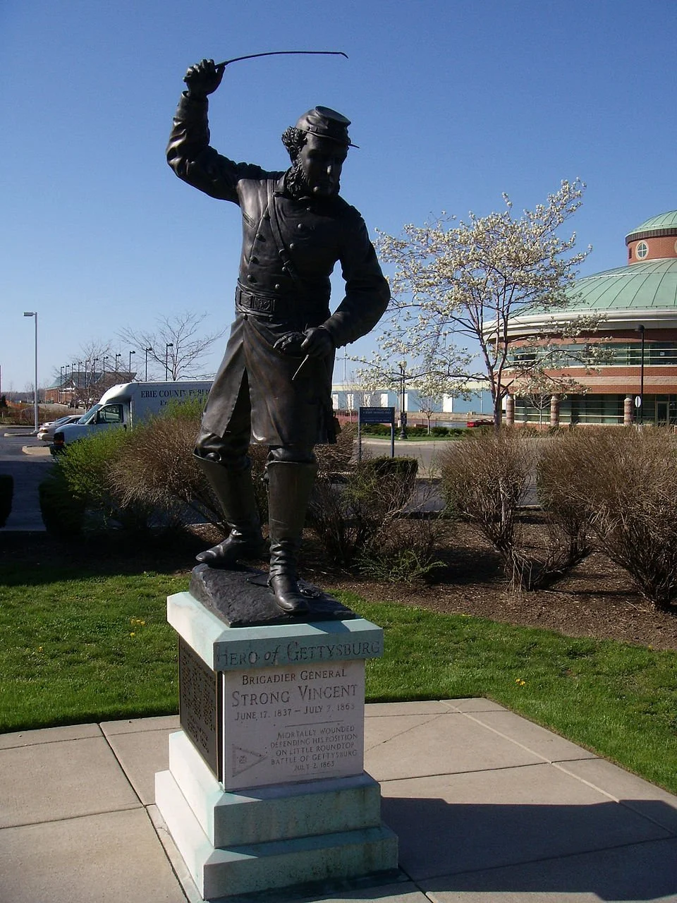
In 1889, a quarter-century after the battle, a monument to the 83rd Pennsylvania was erected on Little Round Top. Back then, the Commonwealth of Pennsylvania’s rules governing Civil War statues forbade memorials that honored individual soldiers. Although it’s clear that the bronze likeness atop the monument was inspired by Vincent, there’s no plaque that explicitly identifies him.
The monument shows the 83rd officer drawing a sword out of a scabbard affixed to his waist, which is not an accurate depiction of Strong Vincent’s actions on the evening of July 2, 1863. In his memoirs, Norton wrote that Vincent was so rushed when he dismounted at the top of the hill that he forgot to grab the scabbard from his saddle. The only “weapon” Vincent was carrying in those fateful minutes was his wife’s riding crop.
The statue of Vincent at Erie’s Blasco Memorial Library, unveiled in 1997, got his heroic stance correct. Not only is he seen waving the riding crop in a menacing way, but he’s depicted looking down – which given the proximity of the enemy when he jumped onto that boulder, was surely the direction he was staring when struck by the fatal bullet.
*
The men that Vincent trained and with whom he fought side-by-side had plenty of war left. After Gettysburg, the Third Brigade and its 83rd Regiment fought in a dozen skirmishes and in such major battles as Spotsylvania, the Wilderness, Cold Harbor, Petersburg, and in April of 1865, the final throes of the conflagration at Appomattox Court House. No brigade in the Union Army fought with greater tenacity, perseverance, or élan.
One of those fighters, John M. Clark, returned home to Meadville, started McCauley & Clark, a wholesale dealership in fine wines, liquors, ales, and cigars. He also ended up the proprietor of two different hotels and, for eight years, served as chief of Meadville’s fire department.
Clark married a local lass named Bessie Banyard in 1862. They had three children and eventually relocated to Snyder in the Oklahoma Territory, where Clark died in 1905, two years before Oklahoma became a state.
The hill that Clark, Oliver Willcox Norton, and Strong Vincent climbed under duress on the evening of July 2, 1863 was a far cry from the arid West. It looked over jagged rocks, some small creeks, a batch of fertile farmland, and off to the north, a charming village with a seminary and a college. It’s not known if Elizabeth Carter Vincent left a remembrance for Clark’s heirs; surely, though, she had a special place in her heart for the Crawford Countian who comforted her while her husband’s body was being laid to rest.
In the months after Gettysburg, Norton enrolled in a special officers training class and become a lieutenant with the Eighth Colored Regiment. In February 1864, he helped lead the Black unit at the Battle of Olustee near Jacksonville, Florida. Olustee did not go well for the Union side. Norton was fortunate that he wasn’t captured, since the Rebels had vowed to execute any White officer caught commanding Black troops.
It took three decades, but Norton finally accepted credit for composing “Taps” in 1862 with General Dan Butterfield, then a Fifth Corps brigade commander. The two worked together in taking an old French marching tune and reshaping it as a 24-note homage to the end of a soldier’s day. After more than a century and a half, the Norton-Butterfield collaboration remains a staple of solemn military occasions, a melancholy tribute to the sacrifice of American soldiers that never fails to move its listeners.
It’s not known if Norton played “Taps” on the evening of July 1, 1863, as the Third Brigade troops pitched their tents outside Hanover, but for posterity’s sake, let’s hope that he did. Soon enough that night, Vincent ordered him to blare “Assembly!”, which eventually sent scores of his mates to their deaths.
Norton became a successful Gilded Age entrepreneur. He and his brother devised a cost-effective method of manufacturing metal cans. At the turn of the 20th century, their company was acquired by the American Can Company, a spinoff from Andrew Carnegie’s U.S. Steel.
In 1889, the onetime schoolteacher was among the speakers as the 83rd’s monument was being unveiled at Gettysburg. “Throwing himself into the breach, [Vincent] rallied his men, but gave up his own life,” Norton said that day. “In the very flower of his young manhood, full of the highest promise, with the love of a young wife filling his thoughts of the future with the fairest visions, proud, gentle, tender, true, he laid his gift at his country’s altar. It was done nobly, gladly.”
General Dan Butterfield, Norton’s “Taps” collaborator, wrote after the war that, “No man who lived and fought in the Battle of Gettysburg did more for his country than Vincent. He was a magnificent soldier, a gentleman of high education and great ability.”
That gentleman of high education was honored by Erie in 1930 when Strong Vincent High School opened. To this day, the school takes up a full city block. Its grand sweep and classic columns are meant to inspire the ideals that Butterfield saw in Vincent: discipline and high moral character. Inspirational quotes are inscribed on the school’s facade, along with the Vincent family coat of arms, an azure shield with a silver and white half-ram above this motto: Vincenti dabitur laurea, “The laurel will be given to the victor.”
After 87 years – Abraham Lincoln’s revered four score and seven – it closed as a high school, having been consolidated with two other city schools. It was converted into a junior high and is still going – as it should – strong.
“Through our great good fortune, in our youth our hearts were touched with fire,” Oliver Wendell Holmes, the great jurist and brevet colonel with the 20th Massachusetts Regiment, wrote of the Civil War generation. “It was given to us to learn at the outset that life is a profound and passionate thing.”
Norton and Clark lived long enough to see the Great War, World War I, decimate a different continent. The pair had fought not only in a great war, but in a Great Cause War.
In the decades following the war, Medal of Honor recipient Joshua Lawrence Chamberlain became something of a beau idéal for the celebration of that cause. Chamberlain delivered scores of speeches all over the country – North and South – saluting the Third Brigade’s heroics. But his most memorable remarks, like Norton’s, came a quarter-century after the battle at the dedication of the 20th Maine’s memorial at Gettysburg.
“The lesson impressed on me as I stand here and my heart and mind traverse your faces, and the years that are gone, is that in a great, momentous struggle like this commemorated here, it is character that tells,” the teacher of rhetoric said that day.
“What I mean by character is a firm and seasoned substance of soul. I mean such qualities or acquirements as intelligence, thoughtfulness, conscientiousness, right-mindedness, patience, fortitude, long-suffering and unconquerable resolve.”
Vincent exhibited all of those qualities, Chamberlain said, when with “earnest and prophetic eyes,” he issued his seminal order not to retreat, no matter the circumstance.
Chamberlain reminded his listeners that Vincent had bellowed into his ear “You understand?”, as Rebel Minié balls tore into the trees around them.
“I did understand with a heavy weight on my mind and spirit,” Chamberlain shared with his mates. “You understood – and it was done. Held – and at what cost?!”
The cost, of course, was grievous – but in the end, utterly worth it. Surely, Strong Vincent sensed what would happen when he leapt onto that boulder. He was our Republic’s Horatius at the most epochal gate in American history.
Now read more on the Battle of Gettysburg here.
Timothy M. Gay is a Pulitzer-nominated author of five books and dozens of articles about history and culture. His most recent book is RORY LAND, which looks at the life of golf superstar Rory McIlroy through the prism of Ireland’s troubled past. A graduate of Georgetown University, Gay grew up in Warren, Pennsylvania, the proud home of a host of Little Round Top heroes in the 83rd Pennsylvania Infantry Regiment.


